White Christmas 2026: Where Snow Is Most Likely
The early outlook points to snow chances in the Rockies and northern states, but a white Christmas will depend on storm timing and temperatures.

The Rockies and northern states have the best starting chances for a snowy holiday, but a white Christmas will depend on where storms track—and whether cold air arrives with them.
With five weeks until Christmas, it’s natural to wonder whether snow will greet you on December 25. The early outlook points to stormy weather over the Rockies and Plains, with heavy snow possible, and unsettled conditions that could bring mountain snow to parts of the Northwest and Southwest. In the Southeast, the outlook calls for dry but unseasonably cold weather.
That’s a broad seasonal picture, not a day-by-day Christmas forecast. The details will depend on how weather patterns develop as the holiday gets closer.
What counts as a white Christmas?
NOAA’s standard is at least 1 inch of snow on the ground at 7 a.m. on Christmas Day. Snow doesn’t have to fall on December 25: snow from an earlier storm counts if enough remains on the ground. Conversely, a few flakes on Christmas morning might not add up to an inch.
That distinction matters. Snow falling on the holiday can make for a memorable scene, but lasting snow cover is what determines whether a location meets the standard.
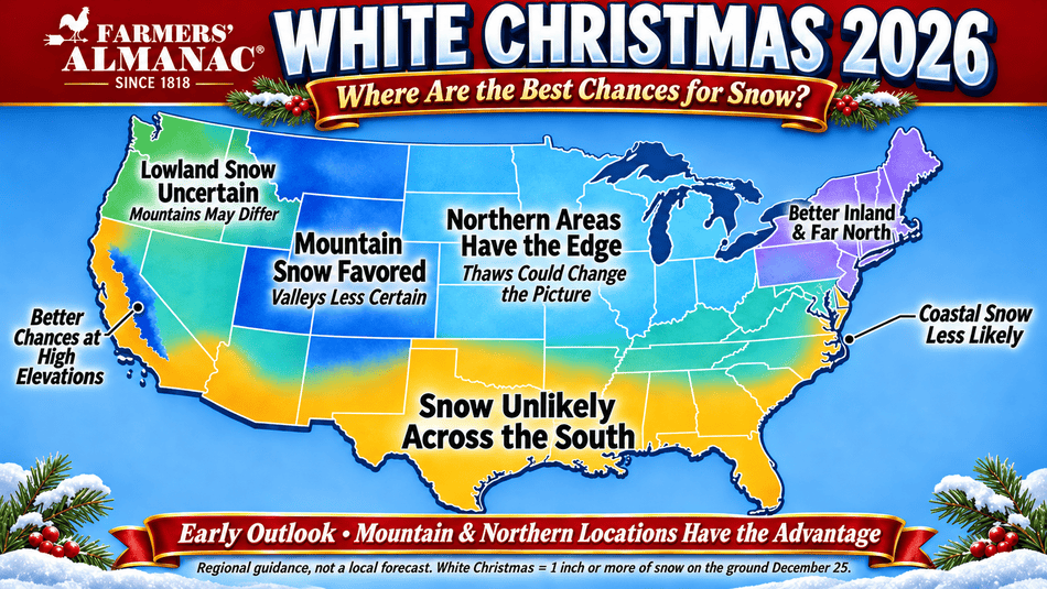
Where could snow be most likely in 2026?
The Rockies and Plains stand out in the Farmers’ Almanac seasonal outlook, which calls for stormy conditions and possible heavy snow. Elevation and local storm tracks will matter, so nearby towns may see very different conditions.
In the Northwest and Southwest highlands, unsettled weather could bring mountain snow. Lower elevations and coastal communities may have a different picture.
Across the Northeast and New England, a white Christmas will depend on the timing and temperature of any storm. Inland and northern areas generally have better historical chances, while coastal locations can see rain or mixed precipitation when temperatures are marginal.
In the Great Lakes and Midwest, snow is possible, but a milder spell could melt snow before Christmas morning.
The Southeast and Gulf Coast may turn cold, but cold weather alone doesn’t make snow. A storm must also bring precipitation while cold air is in place.
See the full Farmers’ Almanac White Christmas 2026 forecast for the regional map, and explore the 2026–2027 winter weather outlook.
What historical odds can—and can’t—tell you
NOAA’s white Christmas map is based on 1991–2020 climate records. It shows where snow on the ground has been more common on December 25, not where it is guaranteed to happen this year.
Northern Minnesota, Michigan’s Upper Peninsula, northern Maine, the Sierra Nevada, and higher parts of the Rockies have some of the strongest historical chances. Southern California, southern Arizona, the Gulf Coast, and much of Florida have low historical chances.
Those averages are useful context, but the weather in the weeks leading up to Christmas decides what happens in 2026. A snowy place can have a green Christmas after a thaw; a place with lower historical odds can still get a surprise storm.
When will the Christmas forecast be clearer?
Five weeks out, forecasts can’t reliably pin down Christmas Day conditions for a specific town. Watch the pattern as the holiday approaches, then check your local forecast during the final week. NOAA recommends checking Weather.gov within seven days of Christmas for the best local information.
For now, the early outlook offers a reason for snow lovers in the Rockies and northern states to keep watching. For everyone else, the Christmas forecast is still taking shape.


- Farmers' Almanac Staff

- Farmers' Almanac Staff
- Farmers' Almanac Staff
- Farmers' Almanac Staff