Atmospheric Rivers: How They Work, Why California Floods, and the AR1-AR5 Scale

Quick Reference
- What it is: A long, narrow corridor of concentrated water vapor moving through the atmosphere, typically 250 to 375 miles wide and over 1,000 miles long.
- How much water: A strong atmospheric river transports more water vapor than the Mississippi River carries on the ground.
- The Pineapple Express: The most famous variety, hauling tropical Pacific moisture from near Hawaii to the West Coast.
- Scale: AR1 (weak/beneficial) through AR5 (exceptional/hazardous), the Ralph scale developed at Scripps Institution of Oceanography.
- How much rain: Roughly 30 to 50 percent of the West Coast’s annual precipitation comes from atmospheric rivers, and 80 percent of West Coast flood damage.
- Worst recent year: Winter 2022-2023 brought 9 consecutive ARs to California, dumping 32 trillion gallons of water and triggering 700+ landslides.

An atmospheric river is a long, narrow corridor of concentrated water vapor that moves through the atmosphere like a river runs through a landscape. The strongest ones can transport more water vapor in a day than the Mississippi River carries on the ground. They are the reason a “Pineapple Express” forecast in California means saturated soil, full reservoirs, mudslides, and headlines for two weeks. Below is what an atmospheric river actually is, the AR1-AR5 scale meteorologists now use to rate them, and why the West Coast lives and dies by them.
What Counts as an Atmospheric River
An atmospheric river is a corridor of moisture in the lower atmosphere, typically 250 to 375 miles wide and 1,000 to 2,000 miles long, fed by evaporation from warm tropical or subtropical oceans. The water moves as vapor (not yet rain) until the corridor reaches land or a mountain range, where it is forced upward, cooled, and condensed into heavy precipitation.
Per NOAA, a strong atmospheric river can transport 7.5 to 15 times the average daily flow of the Mississippi River. That is moisture, not liquid water on the ground; it becomes rain or snow when the river hits the West Coast and runs into the Sierra Nevada or the Cascades.
The Pineapple Express
The Pineapple Express is the most famous and most studied atmospheric river. It originates in the warm Pacific waters near Hawaii, picks up large amounts of tropical moisture, and aims that corridor of water vapor at California, Oregon, Washington, and British Columbia. Pineapple Express events deliver some of California’s heaviest rainfall, the bulk of Sierra Nevada snowpack, and the bulk of the state’s flood disasters.
The AR Scale: AR1 Through AR5
Hurricanes have the Saffir-Simpson scale. Tornadoes have the EF scale. Atmospheric rivers got their own scale in 2019, developed by Marty Ralph and colleagues at the Center for Western Weather and Water Extremes at Scripps Institution of Oceanography. The scale ranks intensity by integrated water vapor transport (IVT) and duration.
AR1 (weak). Primarily beneficial. Helpful rainfall, modest impact.
AR2 (moderate). Mostly beneficial but some hazards.
AR3 (strong). Balanced beneficial and hazardous. Moderate flood risk.
AR4 (extreme). Mostly hazardous. Significant flood risk, dam concerns, mudslides.
AR5 (exceptional). Primarily hazardous. Catastrophic flooding potential. Rare; only a handful per decade.
Why the West Coast Lives by Atmospheric Rivers
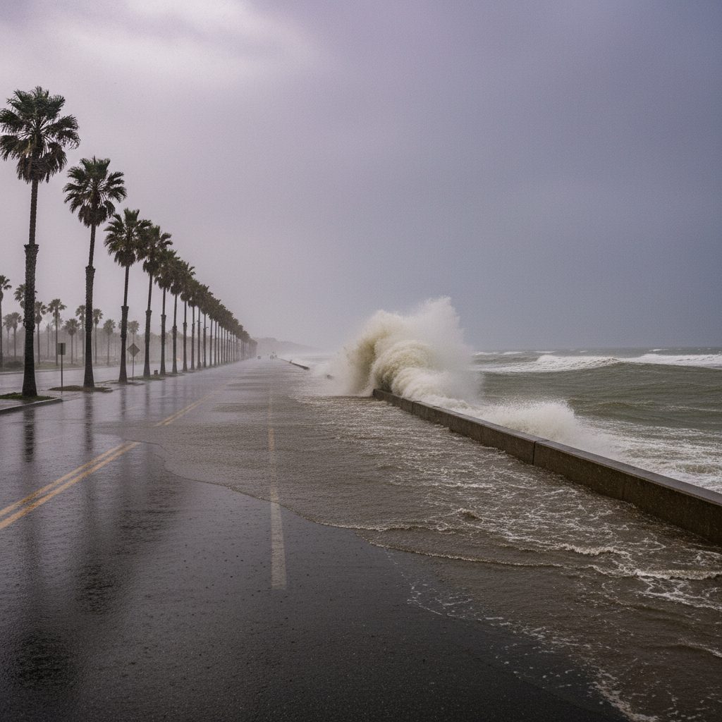
Atmospheric rivers deliver between 30 and 50 percent of the West Coast’s annual precipitation, depending on the location and year. For California specifically, the share runs closer to 50 percent. They are also responsible for roughly 80 percent of West Coast flood damage, which is the trade-off. The same storms that fill the reservoirs and the snowpack also fill the rivers and the basements.
The 2017 Oroville Dam Crisis
In February 2017, a sequence of atmospheric rivers dropped enormous volumes of water on Northern California. Inflow into Lake Oroville, the state’s second-largest reservoir, exceeded the design capacity of the main spillway, which then partially failed. The emergency spillway, never used in the dam’s 49-year history, eroded so quickly that authorities ordered an evacuation of 188,000 people downstream. Repair costs ran more than $1 billion. Atmospheric river research after the event found that warming had amplified the AR’s water content by 11 to 15 percent.
Winter 2022-2023: Nine Rivers in a Row
From late December 2022 through mid-January 2023, California was hit by nine consecutive atmospheric rivers in three weeks. The sequence dumped about 32 trillion gallons of water on the state, triggered more than 700 landslides, killed at least 22 people, and produced an estimated $5 to 7 billion in damage. It was also the moment that ended California’s worst multi-year drought on record. ARs both make and break West Coast water years.
Forecasting: AR Recon Aircraft
Since 2016, NOAA, Scripps, and the U.S. Air Force have flown aircraft (WC-130J Hurricane Hunters and Gulfstream IV jets) directly into atmospheric rivers over the open Pacific. The crews drop instrument packages called dropsondes through the corridor to measure water vapor, wind, and temperature in real time. The program, AR Recon, has improved 3-day West Coast precipitation forecasts by about 12 percent. The same technique has been applied to hurricane forecasting since the 1940s; ARs got the treatment 75 years later.
Climate Trends
Warmer air holds more water vapor, about 7 percent more for every 1 degree Celsius of warming, per the Clausius-Clapeyron relation. Atmospheric rivers, by definition, are vapor-transport features. As the Pacific warms, the strongest ARs are expected to carry more water and produce heavier rainfall. Federal climate projections estimate $2.3 to $3.2 billion in annual AR-related damages by 2090 if current warming trajectories hold.
For broader context on the seasonal climate cycles that influence whether a West Coast winter is wet or dry, see our explainers on El Nino and La Nina.
Atmospheric Rivers Outside the West Coast
Most US atmospheric river research is West Coast focused, but the phenomenon is global. The United Kingdom regularly receives atmospheric rivers from the subtropical Atlantic. The Pacific Northwest of Canada gets the same Pineapple Express that feeds California. East Asia gets ARs that originate over the western Pacific and tropical China Sea. Even the East Coast gets occasional ARs, though they are usually less intense and overshadowed by hurricanes and Nor’easters in the public conversation.
Frequently Asked Questions
What is an atmospheric river?
An atmospheric river is a long, narrow corridor of concentrated water vapor in the lower atmosphere, typically 250 to 375 miles wide and over 1,000 miles long. A strong atmospheric river can transport more water vapor in a day than the Mississippi River carries on the ground.
Why is California so affected by atmospheric rivers?
California sits at the receiving end of the Pacific atmospheric river corridor. Tropical and subtropical Pacific moisture is forced upward by the Sierra Nevada and Coast Ranges, condensing into heavy rain and snow. Roughly 50 percent of California’s annual precipitation and 80 percent of West Coast flood damage comes from atmospheric rivers.
What is the Pineapple Express?
The Pineapple Express is the most well-known atmospheric river, originating near Hawaii and aimed at the US West Coast. It picks up tropical Pacific moisture and delivers heavy rainfall and Sierra Nevada snowpack to California, Oregon, and Washington.
How are atmospheric rivers measured?
The AR scale, developed in 2019 by Marty Ralph at Scripps Institution of Oceanography, ranks atmospheric rivers from AR1 (weak, primarily beneficial) to AR5 (exceptional, primarily hazardous). The ranking uses integrated water vapor transport and duration.
Are atmospheric rivers becoming more intense?
Research indicates yes. Warmer air holds more water vapor (roughly 7 percent more per 1 degree Celsius of warming), so the strongest atmospheric rivers carry more water and produce heavier rainfall in a warmer climate. Federal projections estimate $2.3 to $3.2 billion in annual AR-related damages by 2090 if current warming trajectories continue.
What was the worst recent atmospheric river event?
Winter 2022-2023 brought California 9 consecutive atmospheric rivers over 3 weeks, dumping 32 trillion gallons of water, triggering 700+ landslides, killing 22 people, and causing $5 to 7 billion in damage. The 2017 Oroville Dam crisis was driven by a similar AR sequence and forced 188,000 people to evacuate.


- Josh Morley

- Josh Morley
- Josh Morley