Farmers’ Almanac 2026 / 2027 Winter Weather Forecast
Winter 2026–2027 is shaping up to be a season of sharp contrasts, with an active southern storm track, quick bursts of snow and bitter cold across the North, and a tricky mix of rain, sleet, ice, and heavy wet snow in the Northeast. Keep the shovel, rain boots, and ice scraper close—this winter may bring plenty of surprises.
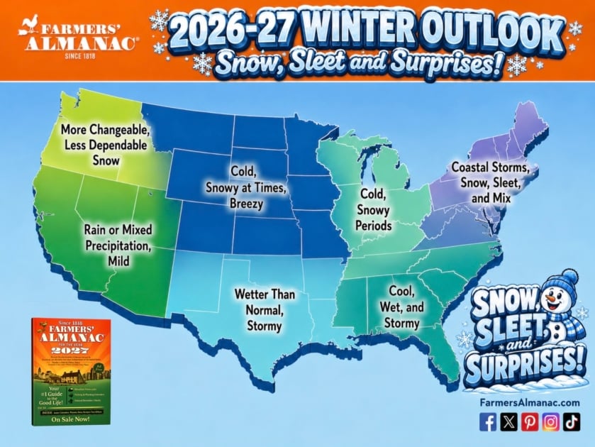
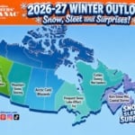
2026 Winter Weather Outlook: Snow, Sleet, and Surprises
The winter of 2026–2027 may deliver sharp contrasts across the country. Some regions could face repeated storms, raw rain, and heavy, wet snow, while others experience milder stretches interrupted by quick cold snaps.
In other words, prepare for a winter of snow, sleet, and surprises.

Our 2026–2027 winter outlook was prepared by Caleb Weatherbee using the same core, proprietary weather formula the Farmers’ Almanac has relied upon since its founding in 1818. First developed by founding editor David Young and passed down from one Almanac forecaster to the next, the time-tested method considers recurring natural cycles, solar activity, lunar influences, and historical weather patterns. Today, those traditional calculations are enhanced—not replaced—by modern forecasting tools, including satellite observations, computer modeling, current meteorological data, historical analogs, and analysis of large-scale ocean and atmospheric patterns. Together, these old and new methods help Caleb develop a broad, long-range regional outlook intended to help readers plan ahead—while remembering that nature always has the final word.
A Wet and Stormy Southern Tier
El Niño is expected to remain an important influence through the heart of the season, favoring wetter-than-normal conditions across much of the southern United States.
An active storm track may extend from Southern California and the Desert Southwest through Texas, the Gulf Coast, and the Southeast. These areas should watch for frequent storm systems, muddy fields, and occasional surges of cold air.
When that colder air meets abundant moisture, some storms could produce sleet, freezing rain, or heavy, wet snow. The southern Rockies may fare especially well for mountain snowfall.
Quick Cold Snaps Across the North
Across much of the West, northern Plains, Upper Midwest, and Great Lakes, temperatures should average near normal overall. However, that does not mean winter will be mild.
Fast-moving clippers, sudden cold snaps, and brief snowy periods are likely, although milder breaks may frequently interrupt the wintry weather. Farther north, the Plains, Midwest, and Great Lakes could experience sudden snow squalls, blustery winds, and bursts of bitter cold.
The middle of the country may also see frequent swings between thawing and freezing, creating rapidly changing road and field conditions.
A Tricky Winter for the Northeast
The Northeast may face one of the season’s most complicated winter patterns.
Coastal communities could receive more rain or mixed precipitation, while inland areas may be hit by several rounds of heavy, wet snow—particularly during January and February.
Small shifts in storm tracks and temperatures could make the difference between rain, sleet, freezing rain, and accumulating snow. Residents should be prepared for forecasts to change quickly as storms approach.
A Changeable Season in the Northwest
The Pacific Northwest may experience a more changeable and somewhat less dependable snow season.
Meanwhile, the northern Plains and Upper Midwest could turn drier at times, especially when the southern storm track becomes dominant. Even so, brief but intense periods of cold, wind, and snow will remain possible.
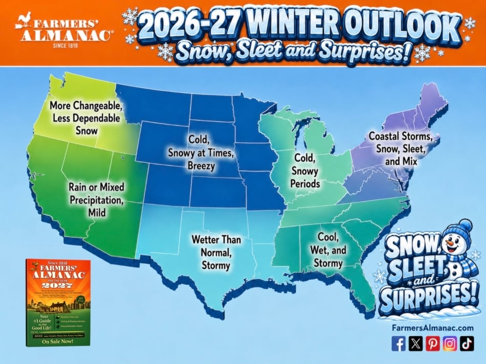

Where Will the Most Precipitation Fall?
A very active southern storm track is expected to bring heavier-than-normal precipitation from California and the Southwest eastward through Texas, the Gulf Coast, and the Southeast.
A second storm path may guide weather systems along the Eastern Seaboard, bringing additional opportunities for rain, wintry mixes, and snow from the mid-Atlantic into New England.
Because temperatures may frequently hover near freezing, precipitation type will be especially difficult to predict. A slight change in temperature or storm direction could turn a cold rain into an icy mix—or transform a slushy snowfall into a significant winter storm.
The Bottom Line
Winter 2026–2027 may be defined by contrasts: an active and wet southern storm track, quick bursts of snow and cold across the North, and a particularly unpredictable mix of precipitation in the Northeast.
Keep the snow shovel, rain boots, and ice scraper close at hand. This winter, you may need all three.

Frequently Asked Questions
How long has the Almanac forecast winter weather?
Since 1818, the same year of the Almanac’s founding. That makes it the longest-running long-range weather forecast in North America.
What is the formula?
A combination of sunspot cycles, lunar position, tidal pull, and historical pattern weighting. The exact details are not publicly published.
How accurate is the forecast?
The Almanac reports 80-85% accuracy on regional outlooks. Independent reviews put actual accuracy somewhat lower, but still meaningfully above chance.
Where can I see the current winter forecast?
On the Almanac’s long-range weather forecast page. The print edition is published each August.
How the Farmers’ Almanac Makes Its Winter Forecast
The Farmers’ Almanac has published long-range weather forecasts since 1818 — 208 consecutive years. Our forecasting method combines three inputs:
- Solar activity: Sunspot cycles have an 11-year rhythm that correlates with large-scale atmospheric circulation patterns. The current Solar Cycle 25 is running hotter than predictions, which affects how the polar vortex behaves in winter.
- Position of the Earth: Earth’s tilt, orbital position, and distance from the sun in a given season shape the baseline energy available. These are computed years in advance with high precision.
- Weather pattern analysis: Long-range oscillation patterns including the Arctic Oscillation (AO), North Atlantic Oscillation (NAO), Pacific Decadal Oscillation (PDO), and the El Niño/La Niña Southern Oscillation (ENSO) are weighted into the regional forecasts.
The formula has been refined continuously since 1818 but the core principle — that the sun’s energy cycle, Earth’s orbital mechanics, and large-scale ocean-atmosphere interactions are the dominant drivers of seasonal weather — remains unchanged. Our forecasts are created up to 18 months in advance, published annually in the printed Almanac and updated online.
What El Niño Means for Winter 2026–2027
A developing El Niño pattern is one of the most significant factors shaping the 2026–2027 winter outlook. NOAA’s August 2026 assessment places the October–December SST anomaly at approximately +2.5–2.7°C, meeting the criteria for a “strong” to potentially “super” El Niño event. El Niño’s strongest winter effects typically peak January through March 2027.
What El Niño typically delivers in a US winter:
| Region | Typical El Niño Winter Effect | 2026–2027 Signal |
|---|---|---|
| Pacific Northwest and Northern California | Drier and warmer than normal; reduced mountain snowpack | Below-normal snowpack likely in Cascades and northern Sierra |
| Southern California and Southwest | Wetter than normal; heavy rain events possible | Above-normal precipitation; potential for flooding in dry desert basins |
| Southern Tier (TX, Gulf Coast, Southeast) | Wetter and cooler than normal; increased storm frequency | Elevated flood and severe weather risk from Texas through the Carolinas |
| Northern Tier (northern Plains, Great Lakes, Northern New England) | Warmer and drier than normal; reduced snowfall | Milder start to winter; cold-snap risk remains despite overall warm tendency |
| Northeast (NY, New England, Mid-Atlantic) | Variable; El Niño signal weakens east of the Appalachians | Changeable pattern; neither clearly mild nor harsh |
El Niño provides a broad probabilistic signal, not a guarantee. In strong El Niño years, the southern tier pattern is highly reliable. The northern tier warming signal is statistically real but weaker — cold intrusions can still occur when the Arctic Oscillation goes negative and polar air breaks south temporarily, even in otherwise mild El Niño winters.
2026–2027 Winter Forecast by Zone
| Zone | States | Temperature Outlook | Precipitation Outlook | Snow Risk |
|---|---|---|---|---|
| Zone 1 – Northeast and New England | NY, VT, NH, ME, MA, CT, RI, PA, NJ, DE, MD, DC | Variable; cold snaps followed by mild stretches | Near-normal; rain events more likely than extended snow periods | Moderate; snowfall possible but not persistent |
| Zone 2 – Great Lakes, Ohio Valley, Midwest | OH, MI, IN, KY, IL, WI | Cold snaps with warmer periods; lake-effect snow in snowbelt | Near-normal overall; lake-effect bursts in Great Lakes snowbelt | Moderate; lake-effect regions above average, interior areas near normal |
| Zone 3 – Southeast | TN, VA, WV, NC, SC, GA, AL, MS, FL | Near-normal to slightly below; wet and stormy | Above-normal; elevated storm and heavy rain frequency | Low; ice possible in Appalachian foothills |
| Zone 4 – North Central | MO, IA, MN, ND, SD, NE, KS, CO, WY, MT | Cold snaps likely despite El Niño warming tendency; periods of warmth | Near-normal; some drought in the northern plains | Moderate; Plains snowfall near-normal; Rockies variable |
| Zone 5 – South Central | AR, LA, OK, TX, NM | Near-normal to slightly below; wet pattern dominates | Above-normal; flooding risk in TX and Gulf States | Low in southern areas; ice events possible in OK and northern TX |
| Zone 6 – Northwest | WA, OR, ID | Near-normal; active storm pattern | Near-normal to above; mountain snowpack below normal Cascades | Above-normal in Cascades and Rockies (ID); below-normal at lower elevations |
| Zone 7 – Southwest | CA, NV, UT, AZ | Near-normal to slightly above; mild in southern CA | Above-normal in southern CA and AZ; drought relief possible | Low at lower elevations; Sierra snowpack uncertain |
For the complete long-range weather forecast, frost dates, and seasonal outlooks, explore the Farmers’ Almanac Extended Forecast and our 2026 Fall Weather Forecast.


Caleb Weatherbee
Caleb Weatherbee is the official forecaster for the Farmers' Almanac. His name is actually a pseudonym that has been passed down through generations of Almanac prognosticators and has been used to conceal the true identity of the men and women behind our predictions.
- Caleb Weatherbee

- Caleb Weatherbee
- Caleb Weatherbee
- Caleb Weatherbee