First Snowfall Where I Live: When Will the First Snow Arrive in 2026?
When will the first snowfall happen where you live? See our U.S. first snow map and typical first snowfall timing from September through winter.

Wondering, “When will the first snowfall happen where I live?” Our map shows when the first snow of the season typically arrives across the United States—from September snow in the highest mountains to December or later across much of the South.
For many people, the first snowfall is the moment the season really changes.
One morning the mountains have a fresh white cap. A few weeks later, flakes are flying across the northern Plains and Upper Midwest. By November, snow is increasingly possible around the Great Lakes and interior Northeast. Yet millions of Americans may wait until December, January—or sometimes all winter—for measurable snow.
So when should you expect the first snowfall where you live?
Our Farmers’ Almanac map provides a broad guide to the typical first snowfall of the season across the United States.
Quick Answer: In the highest elevations of the northern Rockies, the first snow can arrive during August or September. Much of the northern Rockies, northern Plains and Upper Midwest typically sees its first measurable snow in October or early November. Across the Great Lakes and interior Northeast, November is common. Much of the central and Mid-Atlantic U.S. often waits until late November or December, while snow across the Deep South and Gulf Coast is much more variable—and may not occur at all in a given winter.
First Snowfall Map: When Does It Usually Snow Where You Live?
The map divides the Lower 48 into five general first-snowfall periods:
| Map Color | Typical First Snowfall | Areas Most Likely |
|---|---|---|
| Purple | August–Sep. | Highest elevations and far northern mountain areas |
| Blue | Oct. | Northern Rockies, northern Plains, Upper Midwest, parts of northern New England |
| Green | Nov. | Great Lakes, central Rockies, interior Northeast, higher Appalachians |
| Yellow | Late Nov.–Dec. | Central Plains, Ohio Valley, Mid-Atlantic interior, lower-elevation Northwest |
| Light Blue | Dec.–Jan. or rare | Deep South, Gulf Coast, lower Southeast, desert Southwest lowlands and Florida |
Typical First Snowfall Of The Season
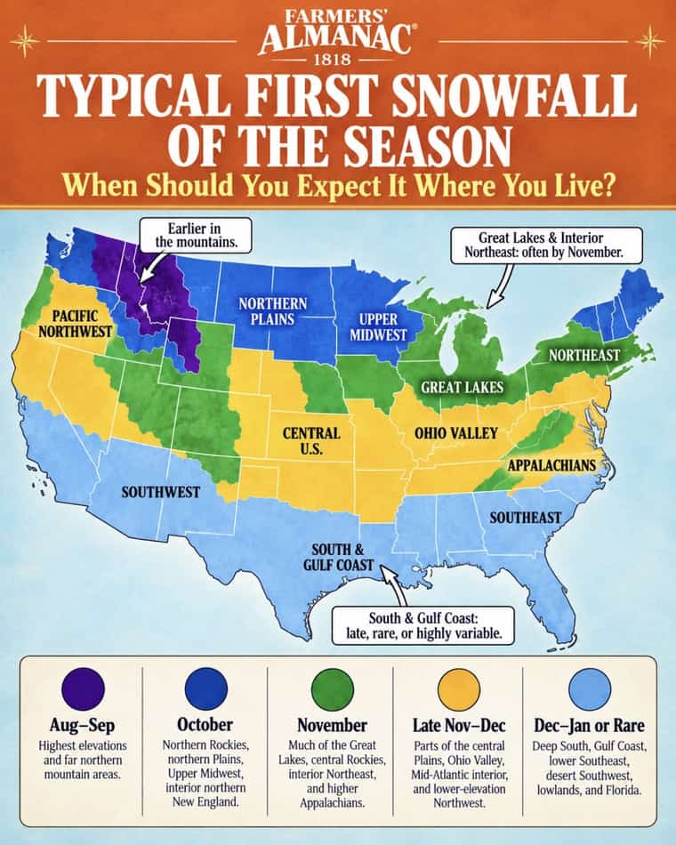
This is a climatological guide rather than a forecast for one particular storm. Elevation, latitude, nearby bodies of water and the weather pattern in a particular year can move the first snow considerably earlier or later.
That variation can be dramatic. Denver’s average first measurable snowfall is around October 18, for example, but the city has experienced its first measurable snow as early as September and as late as December.
Related: Farmers’ Almanac 2026 / 2027 Winter Weather Forecast

What Counts as the “First Snowfall”?
This is more complicated than it sounds.
Meteorologists often distinguish between three milestones:
First flakes: Snow is observed falling, but it may melt immediately and leave nothing on the ground.
First measurable snowfall: At least 0.1 inch of snow accumulates. This is the threshold commonly used by National Weather Service climate records.
First significant snowfall: An inch or more accumulates, making the event much more noticeable—and usually requiring the first shovel of the season.
Those dates can be weeks apart.
In Chicago, for instance, the average first trace of snow occurs around the end of October, while measurable snow generally arrives during November and the first snowfall of an inch or more typically comes later.
For this reason, when someone asks “When is the first snowfall where I live?”, it helps to know whether they mean the first flakes or the first accumulating snow.
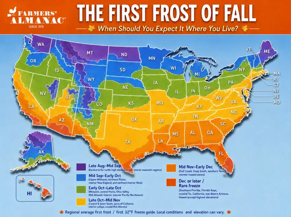
Related Link: First Frost Dates 2026
When Should You Expect Your First Snow?
August–September: The Highest Mountains Get a Head Start
Long before most Americans are thinking about snow shovels, flakes can already be flying at the highest elevations of the Rockies and other northern mountain ranges.
Elevation is enormously important.
Temperatures generally decrease with altitude, meaning a mountain summit can be cold enough for snow while valleys just a few thousand feet below remain comfortably above freezing.
That’s why an early-season storm may turn the high country white even when nearby towns are still enjoying late-summer weather.
An August or September mountain snowfall does not necessarily mean winter has arrived for good. Early snow often melts quickly when warmer weather returns.
October: The Northern Snow Belt Comes Alive
By October, the first measurable snow becomes increasingly common across parts of:
- Montana
- Wyoming
- Colorado
- North Dakota
- northern Minnesota
- higher elevations of Utah and Idaho
- northern New England
Denver’s long-term average date for its first measurable snowfall is October 18, according to the National Weather Service.
But averages hide enormous year-to-year swings. Denver has recorded measurable snow as early as September 3, illustrating how quickly a powerful early-season cold front can change the landscape.
October is also when the boundary between autumn and winter starts racing southward from Canada.
November: First Snow Spreads Across the Great Lakes and Northeast
November is arguably America’s great first-snow month.
As daylight rapidly decreases and increasingly cold Canadian air masses move south, the odds of snow rise across the northern half of the country.
Typical November first-snow areas include much of the:
- Upper Midwest
- Great Lakes
- northern and central Plains
- interior Northeast
- central Rockies
- higher Appalachians
The Twin Cities averages its first measurable snowfall around November 4, while Buffalo averages its first measurable snow around November 8.
Why the Great Lakes Can Get Snow So Quickly
The Great Lakes create one of America’s most famous snow-producing setups.
During autumn, lake water remains relatively warm. When much colder air pours across that water, it can pick up heat and moisture. Once that air reaches land, narrow but intense bands of lake-effect snow can develop.
That is why places such as western New York, northwestern Pennsylvania and parts of Michigan can suddenly go from bare ground to heavy snow while locations relatively close by receive almost nothing.
Buffalo’s National Weather Service office notes that the lake-effect season begins as increasingly cold air crosses the still-warm Great Lakes during late autumn.
Late November–December: Snow Reaches Farther South
By late November and December, the first accumulating snow becomes increasingly possible across:
- Kansas and the central Plains
- Missouri
- the Ohio Valley
- Pennsylvania
- New Jersey
- Maryland
- Virginia
- lower elevations of the Pacific Northwest
- portions of the southern Appalachians
Even here, the timing can vary substantially.
National Weather Service records from the central Plains show that some communities average their first measurable snow during November, while others don’t normally reach that milestone until late November or December.
The lesson: latitude alone doesn’t determine your first snowfall date.
Elevation and storm track can matter just as much.
December, January—or Maybe Not at All: The Deep South
Snow becomes far less predictable as you approach the Gulf Coast.
Places across:
- Louisiana
- Mississippi
- southern Alabama
- southern Georgia
- coastal South Carolina
- Florida
- southern Texas
may go entire winters without measurable snow.
Rather than having a dependable annual first snow date, many southern locations simply have periods of winter when atmospheric conditions are most favorable for a rare snow or ice event.
When southern snow does happen, however, it can be particularly memorable because communities encounter it so infrequently.
Why Does My Neighbor Get Snow Before I Do?
Sometimes two places separated by only 20 or 30 miles can have completely different first-snow dates.
Several factors explain why.
1. Elevation
This is one of the biggest factors. Higher terrain is colder, which is why the Appalachians and Rockies can turn white long before surrounding valleys.
2. Latitude
Northern locations generally cool earlier in autumn because sunlight becomes less direct and days grow shorter more rapidly.
3. The Great Lakes
Lake-effect snow can dramatically increase early-season snowfall immediately downwind of the Great Lakes.
4. The Ocean
Large bodies of water moderate temperature.
That can delay snow along portions of the Atlantic and Pacific coasts compared with inland communities at similar latitudes.
This is why the first snow in interior New England can precede snow along the southern New England coast.
5. Urban Heat
Large cities tend to retain more heat than nearby rural areas.
That extra degree or two can sometimes mean the difference between wet snow sticking to the ground and simply melting on contact.
6. The Year’s Weather Pattern
Perhaps most important of all: averages are not forecasts.
One early Arctic outbreak can deliver snow weeks ahead of schedule. A persistently warm autumn can delay it well beyond the historical average.
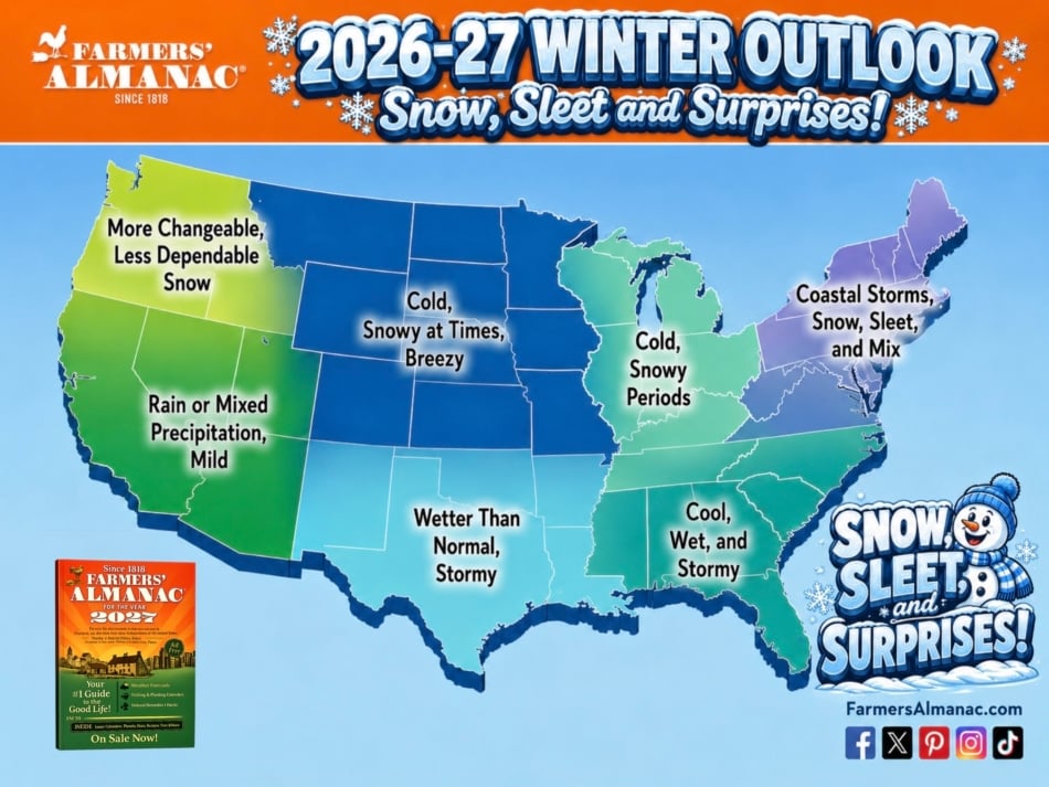
Related Post: 2026–2027 Winter Weather Forecast
Can It Snow Before Winter Officially Begins?
Absolutely.
In fact, much of America’s northern snow belt usually sees at least some chance of snow before astronomical winter begins.
Astronomical winter doesn’t begin until the December solstice. In 2026, winter begins on December 21.
But meteorological winter begins December 1, and cold weather certainly isn’t required to wait for either date.
Snow is simply the result of the right combination of cold air and atmospheric moisture.
Nature doesn’t check the calendar.
Related Post: 2026 Seasons – Dates and Times
Will the First Snowfall Be Early in 2026?
That’s a different question from the map above.
The map tells us when snow typically begins based on climate history. A seasonal forecast tells us whether the particular atmospheric pattern developing this year might favor more snow, less snow, warmth, cold or rapidly changing conditions.
For this winter’s outlook, see our complete Farmers’ Almanac 2026–2027 Winter Weather Forecast, including regional predictions for snow, cold, ice and precipitation. Farmers’ Almanac 2026–2027 Winter Weather Forecast
And remember: your first snow can arrive earlier or later than average even during an otherwise normal winter.
First Snowfall Where I Live: The Bottom Line
If you’re wondering “When will it snow where I live?”, start with your location on the map.
Generally:
September: Highest northern mountains
October: Northern Rockies and parts of the northern Plains
November: Upper Midwest, Great Lakes and interior Northeast
Late November–December: Central U.S., Ohio Valley and much of the Mid-Atlantic
December–January or later: Much of the Deep South
Rarely: Gulf Coast, southern Florida and some desert and coastal areas
But don’t circle one date on the calendar just yet.
The average first snowfall date is a guide, not a guarantee. Some years bring a surprise October snowstorm. Others leave normally snowy places waiting well into December.
And that’s part of what makes the season’s first snow so memorable: you know it’s coming—you just never know exactly when.
Only
$13.99
Per Year
See the next 12 months of this calendar
Become a Farmer’s Almanac member and get access to all the Farmer’s Almanac 1818 information.
Long-Range Gardening Calendar
Weather Forecasts (US & Canada)
Moon Phases
Best Days Calendar
Zodiac Calendar
Cancel any time
First Snowfall FAQ
When is the first snowfall where I live?
It depends primarily on your latitude, elevation and local climate. The highest northern mountains may see snow during September, while much of the Upper Midwest and Northeast usually sees its first measurable snow during October or November. Much of the southern U.S. may wait until December or later.
What month does the first snow usually fall?
For a large portion of the northern United States, October and November are the primary first-snow months. November is particularly common across the Great Lakes, Midwest and interior Northeast.
What is considered measurable snowfall?
The National Weather Service commonly defines measurable snowfall as 0.1 inch or more. A few flakes or a trace of snow may occur earlier without counting as measurable snowfall.
Can the first snowfall happen in September?
Yes. September snow is possible in the northern Rockies, high elevations and occasionally even lower-elevation cities during unusually strong early-season cold outbreaks.
Why does snow fall in the mountains first?
Air temperatures generally become colder with increasing elevation. A mountain peak may therefore be below freezing while nearby valleys remain warm enough for rain.
Does the first snowfall mean winter has begun?
No. Early snow can occur weeks or even months before the winter solstice, and an early snowfall can be followed by a lengthy spell of mild autumn weather.


- Farmers' Almanac Staff

- Farmers' Almanac Staff
- Farmers' Almanac Staff
- Farmers' Almanac Staff