What Is an Alberta Clipper? Speed, Path, and Why It’s Cold
No, it's not a barber or a ship! Learn more about this powerful weather system that comes sweeping down the Plains.
Quick Reference
- What it is: a fast-moving, low-pressure storm system that originates in or near Alberta, Canada, and sweeps southeast across the Northern Plains and Great Lakes.
- Why “clipper”: named after the 19th-century clipper sailing ships, which were built for speed. The storm moves at 30 to 50 mph across the ground, far faster than a typical winter low.
- What it brings: sharp temperature drops (often 20 to 30 degrees F in a few hours), gusty winds up to 45 mph, and light to moderate snow (1 to 4 inches). Not heavy snow on its own.
- When: peak season is December through February. Clippers can occur from late October through early April but are most common when the temperature contrast across the Rockies is sharpest.
- Heavy snow exception: when a clipper crosses one of the Great Lakes, it picks up moisture and can produce 6 to 12+ inches of lake-effect snow on the downwind shore.
An Alberta Clipper is one of the most-named, least-glamorous winter storm systems in North America. It is fast, it is cold, and it is dry. A clipper does not flatten cities the way a Nor’easter does, and it does not bury the Great Lakes the way a lake-effect setup does. What it does, almost without fail, is drop the temperature 20 to 30 degrees in a few hours and rake the Northern Plains, Upper Midwest, and Great Lakes with a sharp burst of cold wind and a few inches of snow before sliding off the East Coast and into the Atlantic. Here is what makes a clipper a clipper, where the name came from, and why the storm is so reliably fast and so reliably cold.
What Is an Alberta Clipper, in Plain English
An Alberta Clipper is a low-pressure storm that forms on the eastern, downwind side of the Canadian Rockies (most often in or near the Canadian province of Alberta, hence the name). It moves rapidly southeast, crossing the U.S. border into Montana or North Dakota, then sweeping across the Northern Plains, the Upper Midwest, the Great Lakes, and into the Northeast or the Mid-Atlantic before exiting over the Atlantic. The whole transit takes 36 to 60 hours.
The signature of a clipper is the speed. A typical Northern-Hemisphere extratropical cyclone moves about 20 to 30 mph across the ground. A clipper moves 30 to 50 mph, sometimes faster. That speed has consequences. The storm does not have time to deepen the way a slower system does, so the central pressure rarely gets very low. The pressure stays moderate, the winds stay strong but not hurricane-grade, and the snow stays light because the clipper is moving too fast to wring out a heavy precipitation column. What it does deliver is a sharp, sudden cold front and a tight band of snow that hits, dumps a couple of inches, and is gone.
Where the Name Comes From
The “clipper” half of the name refers to the 19th-century merchant sailing ships built for speed. Clippers had narrow hulls, tall masts, and lots of canvas. They could outrun anything else under sail, including most warships. The name passed into general English use as a synonym for “fast and lean,” and meteorologists who tracked these fast Canadian-origin storms in the early 20th century borrowed it. The “Alberta” half of the name comes from the most common origin region, the Canadian Prairies just east of the Rockies, with Alberta as the most-frequent specific point of formation.
Clippers do not always start in Alberta. Some form just south of the U.S.-Canada border in Montana, others in Saskatchewan or Manitoba. When they form farther east, regional forecasters sometimes call them by other names: Saskatchewan Screamer, Manitoba Mauler, even Ontario Clipper or just Clipper for short. The names are informal but follow the same convention (province name + something fast or aggressive). Whichever name a forecaster uses, the underlying storm is the same: a fast, dry, lee-side cyclone running on jet-stream momentum.

How a Clipper Forms
A clipper is a textbook example of a process meteorologists call lee cyclogenesis. The Rocky Mountains run north-south across western Canada and the western U.S. Pacific air masses (warm and moist by the time they reach the coast) sweep east, hit the Rockies, and lose most of their moisture as the air rises and cools to make it over the peaks. By the time the air reaches the eastern, downwind side of the mountains, it has dried out significantly and is descending toward the Plains.
Two things happen on the lee side. First, descending air warms slightly through compression. Second, the descending column produces a low-pressure region near the surface. When that low-pressure region forms in winter, with cold Arctic air sitting over the Plains, the temperature contrast across the front edge of the low can be extreme: warmer Pacific air on the north side, frigid Arctic air on the south side. That contrast spins up cyclonic circulation, and a low-pressure system organizes downwind of the mountains.
The clipper is then picked up by the polar jet stream, which in winter often loops down across the U.S.-Canada border and through the Great Lakes. The jet’s wind speeds at the storm’s altitude can run 100 to 150 mph in winter, and that upper-level wind drags the surface low along with it. The storm is, in effect, riding the jet. Hence the speed across the ground.
The Clipper’s Path Across the Continent
A typical clipper track looks like a long arc running from northwest to southeast. The storm forms in or near Alberta, then drops south into Montana or North Dakota within 12 to 18 hours. From there it sweeps across the Northern Plains (Minnesota, Wisconsin, Iowa, Michigan), then into the Great Lakes basin, then through the Mid-Atlantic or southern New England, and finally out over the Atlantic. The entire trip takes 36 to 60 hours from formation to exit.
States and regions hit hardest by clipper passage:
- Northern Plains (Montana, North Dakota, South Dakota, Minnesota): the temperature drop and wind are most dramatic here, often 30 degrees in 4 to 6 hours.
- Upper Midwest (Wisconsin, Michigan, Iowa, northern Illinois): the strongest wind gusts, often 35 to 45 mph, and the most consistent 1 to 4 inches of snow.
- Great Lakes downwind shores (Michigan, northern Indiana, northern Ohio, western New York, far northeastern Ohio): the lake-effect snow exception. A clipper crossing Lake Superior or Lake Michigan picks up moisture and can dump 6 to 12+ inches on the downwind shore.
- Northeast (upstate New York, Vermont, New Hampshire, Maine): light snow and sharp cold, sometimes a small ice event if the storm slows over the Adirondacks.
- Mid-Atlantic (Pennsylvania, New Jersey, Maryland): light snow at the southern edge, often a quick blast that drops half an inch to 2 inches and is gone before the morning commute.
The Southeast and Gulf Coast usually escape clipper effects entirely, since the storm tracks too far north to dip into those regions. Texas, Louisiana, and Florida only see clipper aftermath in the form of the cold air mass that follows, which can produce hard freezes well south of the storm itself.
What a Clipper Brings: Cold and Wind, Not Much Snow
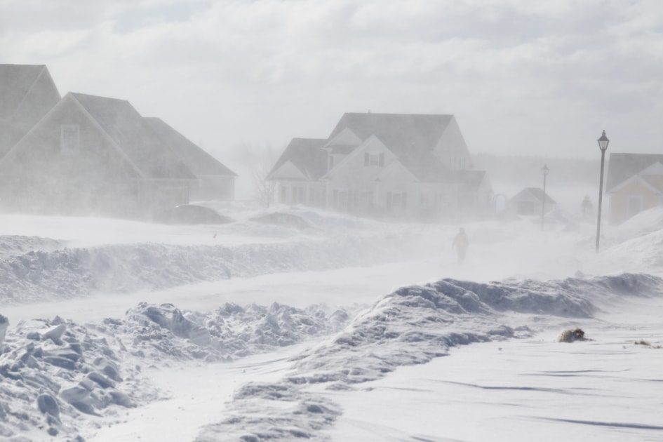
The most consistent feature of a clipper is the cold. Behind the storm front, surface temperatures often drop 20 to 30 degrees F in 4 to 8 hours. A pre-clipper afternoon at 35 F with a damp wet wind can become a post-clipper evening at 5 F with bone-dry Arctic air. The wind compounds the cold; gusts of 30 to 45 mph are common in the open Plains, and the resulting wind chill can run 20 to 30 degrees colder than the air temperature.
The snow is the part that surprises people. Clippers are dry storms by storm-system standards. The Pacific air that fed them gave up most of its moisture crossing the Rockies, and the storm is moving too fast to gather more. Most clipper snow events drop 1 to 3 inches across the storm’s track, occasionally 4 inches in a narrow band. That is not nothing (a clipper can shut down a small Plains town for a morning), but it is far less than a Nor’easter or a Gulf low produces over the same area. The clipper signature is high winds, sharp cold, and a thin, fluffy layer of snow rather than a heavy, wet one.
The Lake-Effect Exception
A clipper that crosses one of the Great Lakes (especially Lake Superior or Lake Michigan, which stay open and warmer than the Arctic air all winter) gets a moisture boost. Cold, dry storm air passes over relatively warm lake water, picks up moisture and energy, and dumps that moisture as snow on the downwind shore. The result is the lake-effect snow band that buries Buffalo, the western Michigan shore, and the Tug Hill Plateau in upstate New York.
Lake-effect bands from a clipper crossing can dump 6 to 12 inches in 12 hours, with isolated totals over 20 inches when the lake fetch is long enough. The contrast between the storm’s snowfall over the open Plains (1 to 3 inches) and over the downwind lake shore (6 to 12+ inches) is one of the most extreme regional snow gradients in U.S. weather. For more on the mechanism, see our lake-effect snow piece.
When Clippers Hit Hardest
Clipper season runs from late October through early April, but the peak window is mid-December through late February. The driver is the temperature contrast across the Rockies. In November and March, the contrast is moderate, and the storms that form are slower and less sharp. In December, January, and February, the Arctic air mass over Canada is at its coldest, the Pacific air arriving over the West Coast is at its mildest, and the contrast is extreme. That is when the storms run fastest, the cold drops hardest, and the wind blows the strongest.
A typical winter sees 6 to 12 distinct Alberta Clippers cross the U.S. between December and February. Some winters produce more (the very cold winters of 1977-1978 and 2013-2014 each saw 15+). Some produce fewer (mild winters with a weak polar jet may see only 4 or 5). The cumulative effect of the clipper count is significant for the Northern Plains; a season with ten clippers will feel notably colder and windier than a season with five, even if the total snowfall is similar.
Famous Alberta Clippers in U.S. Weather History
Most clippers pass without anyone outside the meteorology community noticing. The fast track and modest snow totals mean that no single clipper has the kind of historical legacy that a single Nor’easter or hurricane carries. What clippers produce instead is the cumulative cold of a hard winter. The famous “Polar Vortex” stretches of January 2014 and February 2019 were stitched together from a sequence of clippers running back-to-back, each one delivering another shot of Arctic air after the previous storm exited.
The closest thing to a single famous clipper is the Christmas Day Clipper of 1989, which produced a 30-degree temperature drop in 6 hours across Minnesota, the Dakotas, and Iowa, with wind chills below minus 50 in northern Minnesota. The storm itself was modest (3 to 5 inches of snow across most of its track), but the cold air mass it dragged south reached as far as the Gulf Coast, producing hard freezes in central Florida and ending the citrus harvest two weeks early.
Clipper vs. Nor’easter: How to Tell Them Apart
Both clippers and Nor’easters are winter low-pressure systems, but they form, move, and behave very differently. The differences matter because the right preparation depends on which storm is coming.
- Origin: Clipper forms east of the Rockies, in or near Alberta. Nor’easter forms off the East Coast, often near Cape Hatteras.
- Speed: Clipper moves 30-50 mph. Nor’easter moves 15-25 mph.
- Snow totals: Clipper drops 1-4 inches over most of its track. Nor’easter drops 12-30+ inches in a heavy event.
- Wind: Clipper produces 30-45 mph winds. Nor’easter often produces 50-70 mph along the coast, with hurricane-force gusts in major events.
- Cold: Clipper is the cold storm. Nor’easter often runs at the rain-snow boundary; surface temperatures stay closer to 30 F.
If the forecast calls for a fast-moving storm that will dump cold and wind but only a few inches of snow, that is a clipper. If the forecast calls for a slow-moving storm bringing 18+ inches of snow with hurricane-force coastal winds, that is a Nor’easter. Both can hit the same region the same week, and a season with both produces some of the coldest, snowiest winters on record for the Northeast.
How to Prepare When a Clipper Is Forecast
Clipper prep is different from Nor’easter prep because the threat profile is different. A clipper rarely buries you. It rarely takes out the power for days. What it does is produce sudden, sharp cold that can catch unprepared households and outdoor workers off-guard.
- Watch the temperature drop, not the snow total. The dangerous part of a clipper is the wind chill behind the front. A 35-degree afternoon can become a 5-degree midnight.
- Layer up before the front passes. If you are working outdoors when the clipper hits, you may have 30 minutes to add a layer before the wind chill becomes dangerous.
- Pre-treat the driveway and steps. The thin, dry clipper snow blows around easily and refreezes in the cold air behind the storm. Black ice on driveways and roads is the most common clipper-related injury cause.
- Check on outdoor pets and livestock. A 20-degree drop is harder on animals than a 5-degree continuous cold, because the body has not had time to acclimate.
- Drip the pipes if temperatures fall below 20 F. Cold-and-windy combinations expose plumbing in unheated spaces (crawlspaces, garages) to faster freezing than a steady cold without wind.
Most regional power utilities and emergency services treat clippers as a moderate-tier event. The Northern Plains in particular is well-equipped for clipper passage; municipalities have plows out before the storm, schools delay openings rather than cancel, and most households are stocked with the usual cold-weather essentials. The clipper is, for those regions, a routine winter event. The hazard is for visitors and recent transplants, who do not always know what a 30-degree drop in 4 hours actually feels like.
For the broader winter outlook for your region, including which months are likeliest to produce clipper activity in any given season, see the Farmers’ Almanac long-range forecast. For the official clipper-by-clipper forecast at the storm-system level, the National Weather Service local office is the authoritative source. For broader winter-weather safety guidance, the National Weather Service winter weather safety center covers preparation, frostbite, hypothermia, and travel guidance.
An Alberta Clipper is fast, cold, and dry. Read the temperature trend, prepare for the wind chill, and let the storm pass. The Plains know how to handle them. The visitors are the ones who need the briefing.

Frequently Asked Questions
How fast does an Alberta Clipper move?
Most clippers move 30 to 50 mph across the ground. That is roughly twice the speed of a typical winter low-pressure system. The speed comes from the polar jet stream, which drags the surface low along with it during the storm’s transit.
How much snow does a clipper drop?
Most clippers drop 1 to 4 inches of snow across their track. The exception is when a clipper crosses one of the Great Lakes, which can boost the lake-effect snow on the downwind shore to 6 to 12+ inches.
Why is a clipper called a clipper?
After the 19th-century clipper sailing ships, which were built for speed. Meteorologists in the early 20th century borrowed the term as a label for these fast-moving Canadian-origin storms.
What is the difference between an Alberta Clipper and a Nor’easter?
An Alberta Clipper forms east of the Rockies and moves fast (30-50 mph) with cold and wind but only modest snow. A Nor’easter forms off the East Coast and moves slow (15-25 mph) with heavy snow (12-30+ inches) and strong coastal winds. They are two different storm systems, not variants of the same one.
When is clipper season?
December through February is the peak window. Clippers can occur from late October through early April, but they are most common when the temperature contrast across the Rockies is sharpest, which happens in mid-winter.
Why is a clipper so cold?
A clipper drags Arctic air from northern Canada down across the U.S. behind its cold front. Surface temperatures often drop 20 to 30 degrees F in 4 to 8 hours as the front passes. The wind then compounds the cold through wind chill, often 20 to 30 degrees below air temperature.
Is a Manitoba Mauler the same as an Alberta Clipper?
Yes, just a different province name. Clippers are categorized informally by their origin location: Alberta Clipper, Saskatchewan Screamer, Manitoba Mauler, sometimes Ontario Clipper. The underlying storm system is the same.


Jaime McLeod
Jaime McLeod is a longtime journalist who has written for a wide variety of newspapers, magazines, and websites, including MTV.com. She enjoys the outdoors, growing and eating organic food, and is interested in all aspects of natural wellness.
- Jaime McLeod

- Jaime McLeod
- Jaime McLeod
- Jaime McLeod


The term Albert Clipper was coined by my father, Rheinhart W. Harms, when he researched snow storm patterns originating in Alberta as the Meteorologist in Charge in Milwaukee, Wisconsin. He wrote a paper where he described the pattern and named it. He also described and named the Panhandle Hook, which has its origins in the Oklahoma Panhandle.
Thank you for the info, Harriet!
Thank you for a lively explanation for a term that I have heard all of my life. I was born in 1964 and I can recall that term used all of my life by various individuals, including my late grandmother. It may be of interest that we live in Southern Louisiana…..and every now and then we do get some REAL winter weather. I do believe that we have even been affected by an Alberta clipper or two!