Hurricane Safety Tips: Before, During, and After the Storm
The Atlantic Hurricane season is in full swing! Check out these important tips that can help you weather the storm, before, during, and after a hurricane strikes.
Quick Reference
- Atlantic hurricane season: June 1 to November 30. Peak: mid-August to late October. Climatological peak: second week of September.
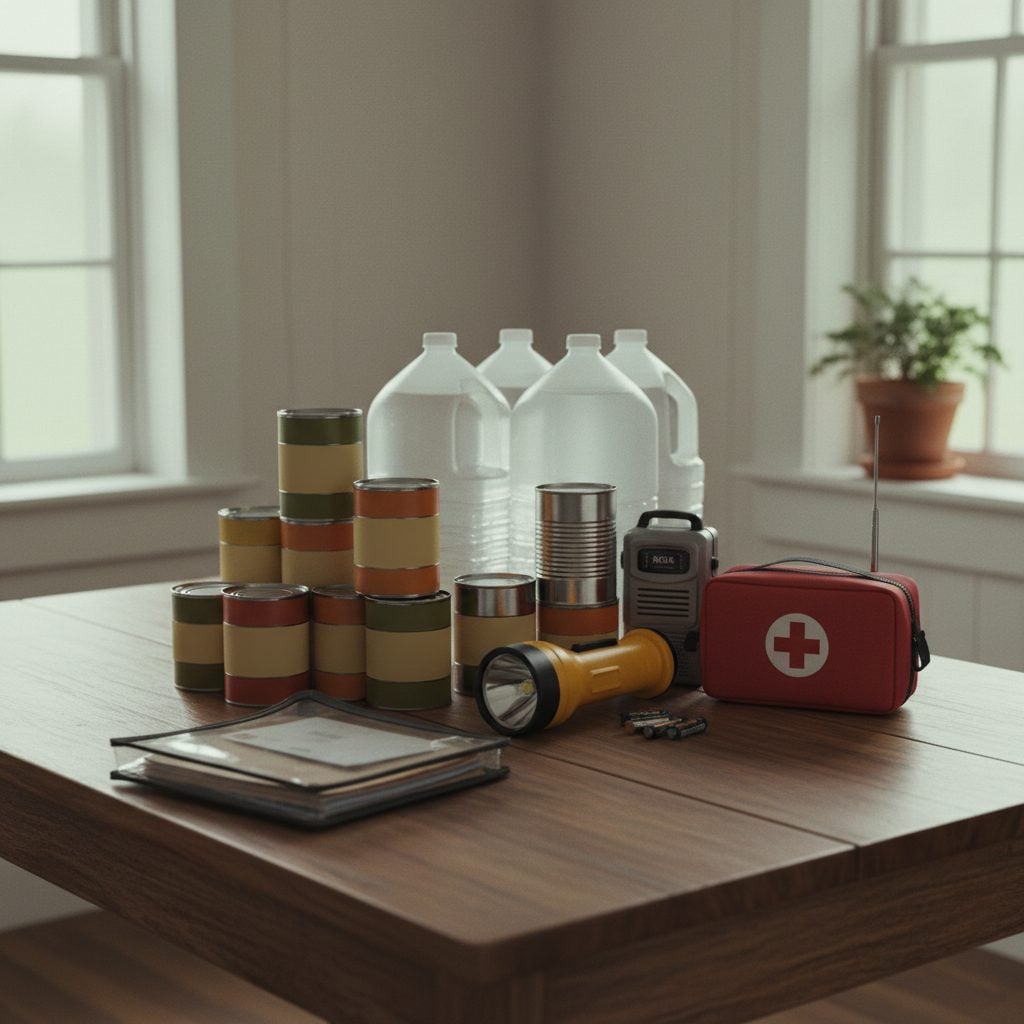
- Pre-season prep: emergency kit (3 days food, 1 gallon water per person per day), evacuation plan, insurance review, NOAA weather radio. Do all of it by May 31.
- Hurricane watch: winds of 39+ mph possible within 48 hours. Begin storm preparations.
- Hurricane warning: winds of 39+ mph expected within 36 hours. Finish prep, decide whether to evacuate. If you live in a mobile home, evacuate.
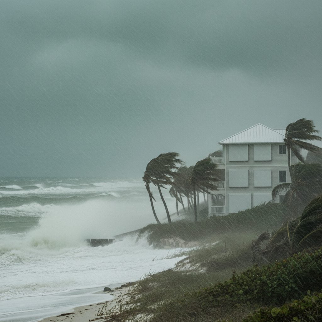
- The biggest killer: storm surge. Inland flooding is the second-biggest. Wind damage gets the headlines but kills fewer people.
The Atlantic hurricane season runs June 1 through November 30 every year, with peak activity in late August through October. Most coastal residents know the timeline. The part that matters is the prep that has to happen before the storm forms, the decisions that have to happen when the watch is issued, and the safety actions that keep families alive during and after landfall. The 2025 season’s Hurricane Melissa (Category 5 strike on Jamaica, killed more than 90 people) was a sharp reminder that the worst storms can still produce mass casualties even with modern forecasting. Here is the complete before-during-after hurricane safety reference, organized so you can use it as a checklist.
Before Hurricane Season: Pre-Season Prep
The window for hurricane prep is April and May. By June 1, when the season officially starts, you should be ready. The key actions:
- Build or refresh your emergency kit. Minimum: 3 days of non-perishable food, 1 gallon of water per person per day, flashlight + extra batteries, first-aid kit, prescription medications (at least 7 days’ supply), important documents in a waterproof container, cash, can opener, baby supplies if applicable, pet supplies if applicable.
- Develop a family disaster plan. Identify two meet-up locations (one near home, one outside the neighborhood). Choose an out-of-state contact every family member can call. Practice the plan once before the season.
- Find out if you live in a flood zone or evacuation zone. Coastal counties publish zone maps on their emergency-management websites. Know your zone, your route, and your destination.
- Review your insurance. Standard homeowners insurance does not cover flood damage. Federal Flood Insurance through NFIP requires a 30-day waiting period before coverage takes effect, so the time to buy is well before any storm forms.
- Document your property. Photograph every room, every major appliance, and every valuable item. Photos make insurance claims dramatically easier if a storm causes damage.
- Sign up for local emergency alerts. Most coastal counties offer notification systems via text, email, or phone. Hurricane warnings come through these channels faster than commercial weather apps.
- Check your NOAA weather radio. If you have one, refresh batteries. If not, buy one. NOAA radios broadcast continuously when other communications are down.
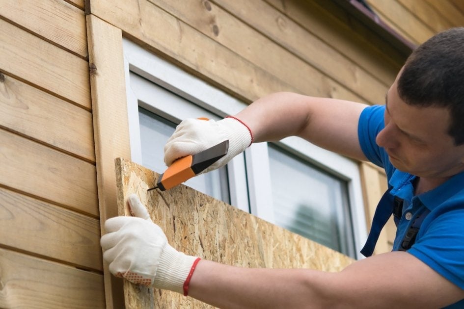
- Trim branches and secure outdoor items. Trees overhanging the roof are the leading cause of structural damage in hurricanes. A pre-season trim of dead branches and weak limbs reduces the risk significantly.
For the upcoming season’s name list, see our hurricane names reference. The 2026 list runs Arthur through Wilfred. Notable retirement: Melissa (replaced by Molly on the 2031 list) following the Category 5 strike on Jamaica in October 2025.
When a Hurricane Watch Is Issued
A tropical storm or hurricane watch means winds of 39 to 73 mph (tropical-storm force) or higher are possible in the next 48 hours. This is the time to begin storm preparations, while the weather is still calm enough to work outside.
- Stock up on non-perishable food. Enough for 3 to 7 days, depending on how far inland you are and how vulnerable your area is.
- Stock up on water. 1 gallon per person per day, for drinking and basic sanitation. Fill bathtubs and large containers before the storm hits.
- Withdraw extra cash. ATMs and credit-card terminals often go down during and after storms. Keep $200 to $500 in small bills.
- Fill your car’s gas tank. Gas stations may close or run dry as the storm approaches. If you need to evacuate, you want to start with a full tank.
- Place IDs, insurance documents, cash, and valuables in a waterproof container. Take it with you if you evacuate.
- Close, lock, and cover windows. Storm shutters or 3/4-inch plywood. Painter’s tape across glass does not prevent breakage; it just changes how the glass shatters. Skip the tape and use real shutters or boards.
- Secure lawn furniture, garbage bins, grills, and other loose objects. A 100 mph wind turns a garbage can into a missile.
- Bring pets indoors. Prepare a pet emergency kit with food, water, leash, carrier, vaccination records, and a recent photo.
- Move livestock to higher ground or, if possible, evacuate them entirely.
- Decide whether to evacuate or shelter in place. Make the call early. The roads will be much harder to navigate as the storm approaches.
When a Hurricane Warning Is Issued
A tropical storm or hurricane warning means tropical-storm-force or hurricane-force winds are expected within 36 hours. This is the final prep window. If a mandatory evacuation has been ordered, leave immediately rather than finishing prep.
- If you live in a mobile home or trailer, evacuate. Mobile homes do not survive hurricane-force winds, even reinforced ones. The leading cause of hurricane fatality in some storms is mobile-home destruction.
- Charge cell phones and backup batteries to 100 percent. Power may be out for days after the storm.
- Fill clean bathtubs and sinks with water. This water is for flushing toilets and other sanitary uses, not drinking.
- Shut off propane tanks and fuel lines. Reduces fire risk if the structure is damaged.
- Unplug major appliances. Reduces damage from power surges as the grid fails and recovers.
- Move possessions to the highest level of your home. Especially documents, photos, and irreplaceable items.
- Listen to local officials. Mandatory evacuation orders are issued for areas where the storm will be life-threatening. Honor them. Voluntary evacuation orders are also worth taking seriously, especially if you have any reason to be unsure about the storm.

During the Hurricane: Sheltering in Place
If you have decided not to evacuate (or if a mandatory evacuation was not ordered), the safe sheltering strategy:
- Move to a small, interior, windowless room on the lowest floor. A bathroom, walk-in closet, or hallway closet works well. Walls between you and the wind reduce the risk from breaking glass and flying debris.
- Stay there until the storm has fully passed. The temptation to step outside during the eye is dangerous; the eye produces a brief calm followed by the back wall of the storm with hurricane-force winds from the opposite direction.
- Wear shoes or rain boots. Even inside the house. Broken glass and flooding water are common after a hurricane passes; protected feet matter.
- Use generators only outdoors and away from windows. Carbon monoxide from generators kills hundreds of post-hurricane survivors every active season. Generators should be at least 20 feet from any door, window, or vent.
- Keep flashlights and battery lanterns ready. Avoid candles; the post-storm fire risk from open flames is high.
- Listen to your weather radio. NOAA broadcasts continue even when other communications are down.
- Stay away from windows and exterior doors. Even in your shelter room, do not press against exterior walls.
The eye of a hurricane is a deceptive moment. The wind drops to near-calm, the sky may briefly clear, and many people make the mistake of going outside to assess damage. Within 30 minutes, the back wall of the eye arrives with full hurricane-force winds, often coming from the opposite direction. Several deaths every active season happen during the eye-passage window.
After the Hurricane: Recovery Safety
The hurricane’s passage does not end the danger. Post-storm hazards account for a significant share of total hurricane fatalities. The most important post-storm safety actions:
- Wait for local officials to confirm it is safe to return if you evacuated. Coastal areas can remain dangerous for days after the storm passes due to flooding, downed lines, structural damage, and contamination.
- Keep using bottled water until local officials say tap water is safe. Storm flooding often contaminates municipal water systems.
- Avoid floodwater contact. Flood water can carry sewage, chemicals, downed power lines, snakes, and disease vectors. Six inches of fast-moving water can knock over an adult; 1 to 2 feet can wash away a vehicle.
- Stay away from downed and low-hanging power lines. Assume every downed line is live until utility crews say otherwise. Report downed lines to the utility immediately.
- Walk pets on a leash and stay with them. Disoriented pets can wander into hazards.
- If phone calls won’t go through, send a text. Texts use less bandwidth and often get through busy circuits when calls fail.
- Document property damage with photographs before moving or repairing anything, for insurance purposes.
- Check on neighbors, especially elderly people and those with medical conditions.
- Watch for carbon monoxide. Generators, gas stoves, and grills used indoors are common post-storm CO sources. Symptoms: headache, dizziness, nausea, weakness, confusion. Get outside immediately if you suspect CO exposure.
The Threats Inside a Hurricane
Hurricanes kill people through several mechanisms, and understanding the relative threats shapes the right response:
- Storm surge: the biggest killer in most major hurricanes. A 10 to 30 foot wall of seawater driven inland by the storm. Most U.S. hurricane fatalities since 1900 have come from storm surge.
- Inland flooding: the second-biggest killer. Hurricane rainfall can dump 10 to 30+ inches over multiple days, producing river and stream flooding hundreds of miles inland from the coast.
- Wind damage: structural damage and flying debris from hurricane-force winds. The headlines focus here, but wind kills fewer people than water.
- Tornadoes: hurricanes often spawn tornadoes in the rain bands east of the eye. The tornado threat persists for 24 hours after landfall in many storms.
- Post-storm hazards: downed lines (electrocution), structural collapse, carbon monoxide, contaminated water, and floodwater drowning all take additional lives in the recovery period.
The “run from water, hide from wind” rule of thumb is a useful heuristic. Storm surge and inland flooding require evacuation away from the coast and away from flood-prone areas. Wind requires sheltering in a sturdy interior space. Both require pre-season prep so you can act fast when the storm forms.
For more on the radar and detection technology that produces the warnings you act on, see our Doppler radar piece. For the history of how Atlantic storms get their names, see why hurricanes are named. For the year-by-year list of upcoming names, see hurricane names. For the official federal hurricane preparedness reference, FEMA maintains a comprehensive guide at Ready.gov.

Frequently Asked Questions
When does the Atlantic hurricane season start in 2026?
June 1, 2026. The season runs through November 30, with peak activity from mid-August to late October. The climatological peak is the second week of September.
What is the difference between a hurricane watch and a warning?
A watch means hurricane conditions are possible within 48 hours. A warning means hurricane conditions are expected within 36 hours. Watch = begin preparations. Warning = finish prep, decide whether to evacuate.
Should I evacuate if I’m not in a mandatory evacuation zone?
If a mandatory evacuation has been ordered for your zone, yes. If only a voluntary evacuation has been issued, weigh the storm strength, your home’s construction, your supplies, and your medical needs. If you live in a mobile home, evacuate regardless. If you have any doubt about your shelter’s ability to handle hurricane-force winds, evacuate.
What kills the most people in hurricanes?
Storm surge is the biggest killer in most major hurricanes. Inland flooding is second. Wind damage gets the headlines but kills fewer people than the water threats. The “run from water, hide from wind” rule reflects this priority.
What should be in a hurricane emergency kit?
3 days of non-perishable food, 1 gallon of water per person per day, flashlight + batteries, first-aid kit, prescription medications (7+ days), important documents in waterproof container, cash, can opener, NOAA weather radio, baby and pet supplies as applicable.
Is it safe to go outside during the eye of a hurricane?
No. The eye produces a brief calm of 30 to 60 minutes, followed by the back wall of the storm with hurricane-force winds from the opposite direction. Several hurricane fatalities every season happen during the eye-passage window when people leave shelter too early.
Will the 2026 hurricane season be active?
Probably moderate. NOAA’s spring 2026 outlook gives a 61% chance of El Nino emerging in May-July 2026, which would suppress Atlantic activity. Most current outlooks call for 12 to 17 named storms, 5 to 8 hurricanes, and 2 to 3 major hurricanes. Pre-season outlooks from NOAA, CSU, and the Farmers’ Almanac will be finalized in late May.


Tiffany Means
Tiffany Means is a freelance writer and a degreed meteorologist. She specializes in weather forecasting and enjoys making the subject of weather (and the science behind it) more relatable. She currently resides in the Blue Ridge Mountains of North Carolina.
- Tiffany Means

- Tiffany Means
- Tiffany Means
- Tiffany Means


You can fill up outside trash ans with water for flushing.
Please be careful !!! Pay attendance to weather reports !