8 Weird Weather Terms (and What They Actually Mean)
Check out our top picks for weird weather terms.
Quick Reference
- Strangest names: dust devil, mackerel sky, gully washer, mare’s tail, knot, Indian summer, snow eater, haboob.
- Where they come from: sailors’ lore, desert wind, Rocky Mountain Chinook, Arabic, colonial New England.
- Most useful for forecasting: mackerel sky and mare’s tail, both early signals of stormy weather to come.
- Largest scale: haboob, walls of dust several miles high.
Weather has its own vocabulary, most of it built up over centuries by sailors, farmers, and frontier settlers who needed a fast way to name what they were seeing in the sky. A lot of those terms are still on the books and in active use at the National Weather Service. Here are eight weird weather terms that sound like inventions but are not, plus the lore and the science behind each one.
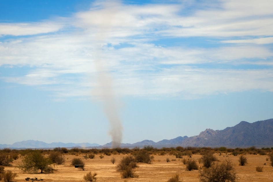
1. Dust Devil
A dust devil is a rapidly rotating column of air that swirls dust, debris, and sand to great heights, and superficially resembles a small tornado. The mechanism is straightforward: superheated air just above sun-baked ground rises into cooler air above it, the column starts to spin, and any loose surface material gets carried up into the visible plume. Dust devils tend to be small, three feet across or less. The largest on record have grown to over 300 feet wide, with debris carried hundreds of feet into the air.
Other names for the same phenomenon include dancing devil, sun devil, and whirling dervish. Cousins of the dust devil include the waterspout, which forms over a body of water, and the snow devil, which is a whirling column of snow over an open snowfield. Mars produces dust devils on a regular basis, and NASA’s rovers have photographed and tracked them as part of the Martian weather record.
2. Mackerel Sky
A mackerel sky is a formation of cirrocumulus or altocumulus clouds that look like the pattern of scales on a mackerel’s back: small puffy patches lined up in rippled rows across a wide stretch of sky. Sailors used to read it as a warning of weather to come and put it into a couplet that is still in the lore books:
Mackerel sky, mackerel sky.
Never long wet and never long dry.
The reading holds up reasonably well today. Cirrocumulus clouds are usually a sign that warm moist air is moving in over a cold front, which often produces unsettled weather within 24 to 48 hours. In some parts of the country, a mackerel sky is also called a buttermilk sky.
3. Gully Washer
A gully washer is an extremely heavy downpour, usually short, that drops enough rain in enough time to flood the ditches and gullies along roads and farm fields. The flash flooding is the part that gives the term its name. The rain runs off the bone-dry ground (or off saturated ground that cannot absorb any more) and into the lowest line of the landscape, where it fills the gullies and washes them out.
Gully washers are most common in summer in the Plains and the Southeast, where afternoon thunderstorms can drop two to four inches of rain in less than an hour. In dry country, they are a real road hazard: a road that is dust-dry one minute can have a foot of running water across it ten minutes later.
4. Mare’s Tail
A mare’s tail is a formation of cirrus clouds that are wispy and stretch across the sky like the tail of a horse blowing in the wind. Cirrus clouds form at high altitude, usually above 20,000 feet, and are made of ice crystals. The wisp shape comes from upper-level winds blowing the ice crystals out into long streamers as they fall.
The classic weather lore couplet pairs mare’s tails with the mackerel sky:
Mackerel scales and mare’s tails
make lofty ships carry low sails.
The reading: when both kinds of clouds appear together, sailors took in canvas because storm conditions were almost certainly coming. Modern meteorology backs the rule. The two cloud types together usually mean a warm front is approaching with rain or wind within a day or so.
5. Knot
A knot is a unit of speed equal to one nautical mile per hour, or about 1.151 statute miles per hour. The name comes from how sailors used to measure a ship’s speed before mechanical instruments. They tossed a wedge-shaped wooden float on a long rope (called a log line) overboard and let the rope pay out as the ship sailed forward. Knots were tied in the rope at fixed intervals. They counted the knots that ran past the rail in 30 seconds, and that count gave them the ship’s speed in knots.
Modern weather forecasts still report wind speed in knots in marine and aviation contexts. One knot equals about 1.15 mph or 1.85 km/h. A 30-knot wind is roughly 35 mph, which is the threshold the National Weather Service uses for a small-craft advisory.
6. Indian Summer
Indian summer is a stretch of unusually mild, dry, sometimes hazy weather that arrives in late autumn or early winter, usually after the first hard frost. The window is short, often just a week, and the temperatures during it can run 15 or 20 degrees above the seasonal average.
The origin of the name is uncertain, with several competing accounts in the historical record. The most commonly cited explanation is that early colonial English settlers used the word “Indian” to mean “false,” so an Indian summer was a false summer that fooled people into thinking the cold season was over. Other accounts trace the term to Algonquin and Abenaki seasonal observations, or to colonial-era hunting and harvest patterns. The phrase shows up in print in New England from the late 1700s onward.
7. Snow Eater
A snow eater is a warm, dry wind that blows over snowy terrain and melts the snow at a stunning pace. The term is most often used in the Rockies, where the same wind is also called a Chinook. A Chinook can raise the air temperature by 40 degrees Fahrenheit in less than an hour and strip a foot of snow off the landscape in an afternoon.
The mechanism is a foehn effect: moist Pacific air is forced up the windward side of the Rockies, drops its moisture as snow, then descends on the lee (eastern) side warmer and drier than it started. The official record temperature change for a Chinook is the Loma, Montana event of January 15, 1972, when the temperature rose 103 degrees in 24 hours, from minus 54 to plus 49.
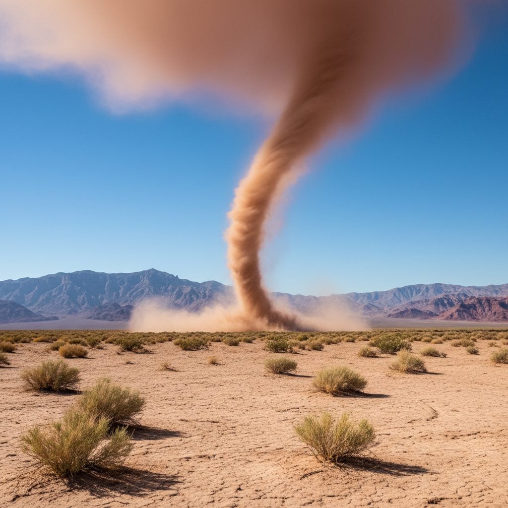
8. Haboob
A haboob is a large, severe dust storm that forms in arid regions, usually on the leading edge of a thunderstorm downdraft. The name comes from the Arabic word “habb,” meaning “blasting” or “drifting.” Haboobs are common on the Arabian Peninsula and across North Africa. North America has its own haboob country in the desert Southwest, particularly Arizona, where the Phoenix metro area sees several haboobs each summer.
The visual is the part that earns the term. A haboob can be a wall of dust several miles high and tens of miles wide, advancing across the desert at 30 to 60 mph. Visibility inside the wall drops to near zero. Buildings, cars, highways, and people get swallowed up for the duration, which is usually 10 to 30 minutes. The Phoenix haboob of July 5, 2011 became the canonical recent example, with a dust wall photographed at over 5,000 feet tall.
More Weird Weather Terms Worth Knowing
The eight terms above are the start. The Farmers’ Almanac weather glossary tracks dozens more, including:
- Bombogenesis, when a storm’s central pressure drops 24 millibars in 24 hours.
- Derecho, a long-lived, straight-line windstorm that can travel hundreds of miles.
- Bugnado, a swarm of insects rotating in a column, often mistaken for a tornado.
- Onion snow, a late-spring snow that falls just as the onions are being planted.
- Dogwood winter, a cold snap that arrives just as the dogwoods bloom.
Why Reading the Sky Still Matters
The terms came from people who needed to forecast the weather without a phone in their pocket. Modern apps and short-range forecasts have replaced most of that work, but the old vocabulary still maps onto real atmospheric conditions. A mackerel sky still warns of an approaching front. A mare’s tail still says rain or wind is on the way. A snow eater still strips a snowpack in an afternoon. Knowing the names sharpens what you see when you step outside, and gives you a faster way to read the sky than checking your phone.
Watch the sky. Read the signs. The forecast is on the way.
Frequently Asked Questions
What is the strangest weather term in everyday use?
Haboob is usually the one that surprises people, because it sounds like an invented word but is from Arabic, has been in the meteorology vocabulary for over a century, and describes a real and dangerous phenomenon you can see live in Phoenix every summer.
Are mackerel sky and mare’s tail real forecast tools?
Yes. Both are early signals of an approaching front. A mackerel sky is cirrocumulus, a mare’s tail is cirrus. Together they almost always mean rain or wind within 24 to 48 hours. Sailors learned to read them centuries ago and modern meteorology confirms the pattern.
Why is wind speed measured in knots?
The unit comes from the sailing-era practice of throwing a knotted rope overboard and counting the knots that paid out in 30 seconds. The number of knots equalled the ship’s speed in nautical miles per hour. Marine and aviation forecasts still use knots today because the unit lines up cleanly with nautical miles and latitude lines.
What is the difference between a Chinook and a snow eater?
They are the same wind. Chinook is the more formal name and the one used in atmospheric science. Snow eater is the older folk term, used by ranchers and frontier settlers in the Rocky Mountain states. Both refer to a warm dry wind that descends the lee side of the Rockies and melts snow on contact.
Is Indian summer always after the first frost?
By the strictest definition, yes. The mild stretch only counts as Indian summer if it follows the first hard frost of autumn. A warm spell in early October that comes before any frost is just a warm October. The frost-first rule is what makes the warm spell feel like a return of summer rather than a delay of winter.
Where do haboobs happen in the United States?
Mostly Arizona, with the Phoenix metro area as the recurring stage. Smaller haboobs also show up across the desert Southwest, especially New Mexico and southeastern California. They form on the leading edge of summer thunderstorm downdrafts and tend to roll across the desert at 30 to 60 mph.
Are dust devils dangerous?
Most are harmless. The typical dust devil is a few feet wide and lasts under a minute. Larger ones, especially those over 100 feet wide, can carry roofing material, toss patio furniture, and have caused injuries and the occasional death when they pass over crowds at outdoor events.


Kristen Hewitt
After graduating from Bates College in 2009, Kristen attended the Salt Institute for Documentary Studies in Maine. She lives in Western Massachusetts where she works at Orion magazine."
- Kristen Hewitt

- Kristen Hewitt
- Kristen Hewitt


In 1970 while visiting relatives near lake Bridgeport (Texas) I encountered something unusual. A dust storm from the west met a line of thunderstorms from the north, for a good while it rained mud.
Wow, Carl, I bet that was interesting!
I find it interesting.