Crazy Clouds: 12 Unusual Cloud Formations and What They Mean
We bet you’ve never seen clouds like these before! Find out what these unusual formations mean!

Quick Reference
- Most dangerous formation: mammatus and shelf clouds. Both signal severe storm activity.
- Most beautiful: Kelvin-Helmholtz waves and lenticular saucers.
- Rarest: Morning Glory roll clouds, found mostly over Cape York Peninsula in Australia.
- Newest classification: asperitas clouds, officially recognised by the World Meteorological Organization in 2017 as the first new cloud type added in 67 years.
- How to use this: learning the unusual formations sharpens your ability to read the sky for what is coming next.
Most clouds fit neatly into one of the ten basic categories taught in school: cirrus, cirrocumulus, cirrostratus, altocumulus, altostratus, nimbostratus, cumulus, cumulonimbus, stratocumulus, and stratus. Most do, but not all. Some clouds form in patterns so unusual they get their own classification, their own name, and their own folklore. Here are twelve of the strangest cloud types in the sky, how each one forms, and what each one is telling you about the weather to come.
1. Anvil Clouds
Anvil clouds are a subtype of cumulonimbus, the towering thunderhead that produces severe storms. The flat, anvil-shaped top forms when the rising column of warm air hits the tropopause (the top of the lower atmosphere) and spreads horizontally because it cannot rise any further. The result is the unmistakable mushroom-with-a-flat-top shape. An anvil cloud overhead almost always signals an active or imminent thunderstorm. The “leaning anvil” pattern, where the anvil top spreads predominantly in one direction, points to the direction the storm is moving. If the anvil leans toward you, the storm is heading your way.
2. Cirrus Kelvin-Helmholtz Clouds
Kelvin-Helmholtz clouds look like a row of breaking ocean waves frozen in the sky. They form when two layers of air slide past each other at different speeds, creating a shear instability at the boundary between them. The boundary curls up into a wave pattern (named after the 19th-century physicists Lord Kelvin and Hermann von Helmholtz, who described the underlying fluid mechanics). Kelvin-Helmholtz clouds are short-lived, often lasting only a minute or two before the wave shape dissipates. Pilots use them as visual confirmation of wind shear at altitude, which is why these clouds are sometimes spotted in turbulent air over the Rockies and the Alps.
3. Fallstreak Hole Clouds
Also called hole-punch clouds, fallstreak holes are large round gaps in a uniform cloud layer, often with wispy streaks of falling ice in the middle. They form when supercooled water droplets (water vapor below freezing temperature that has not yet crystallised) suddenly freeze, usually triggered by a passing aircraft or a chunk of ice falling from above. The freezing droplets create ice crystals that fall away, and the surrounding water droplets evaporate to balance the local air saturation. The result is a clean round gap in the cloud, sometimes a quarter mile across.
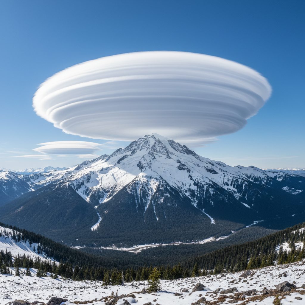
4. Lenticular Clouds
Lenticular clouds are saucer-shaped, often layered like a stack of dinner plates. They form when stable, moist air flows over a mountain ridge or other terrain feature and gets pushed upward into a wave pattern. The cloud forms at the crest of each wave, where the air cools enough for water vapor to condense, and dissipates at the trough. The result is a stationary, lens-shaped cloud that can hover over the same spot for hours. Lenticulars are most common around the Rockies, the Sierra Nevada, the Cascades, and the Appalachians. They are also the cloud most often mistaken for UFOs in photographs.
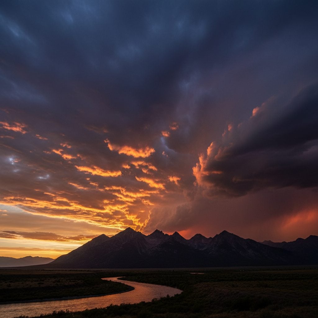
5. Mammatus Clouds
Mammatus clouds look like a layer of pendulous bumps hanging down from the underside of a larger cloud, usually a thunderstorm anvil. The shape is unusual because most clouds bulge upward, not downward. Mammatus form when pockets of cooled, moisture-laden air sink below the surrounding air at the base of a cumulonimbus cloud. The negative buoyancy creates the drooping pouch shape. Mammatus clouds are almost always associated with severe thunderstorms and often appear in the wake of a major storm cell. Seeing them overhead means the worst is usually behind you, but the storm itself was strong.
6. Roll Clouds (and Morning Glory)
Roll clouds are long, perfectly cylindrical formations that appear to roll along like a log laid horizontally across the sky. They form along the leading edge of cool air masses, often along coastlines, where cool sea air meets warmer land air. The boundary curls into a tube shape that the cloud condenses inside.
The most famous roll cloud is the Morning Glory of Cape York Peninsula in northern Australia. This particular formation can stretch over 600 miles in length and produces predictable enough weather conditions that glider pilots travel from around the world to surf the leading edge of the cloud. Morning Glory clouds form roughly 10 days a year between September and November, and the tiny town of Burketown has become an unlikely glider destination because of them.
7. Shelf Clouds
Shelf clouds are wedge-shaped formations that form along the leading edge of a thunderstorm, attached to the parent storm cloud. They appear flat on the bottom, often with a stepped or laddered structure rising back into the storm. Shelf clouds form when cool downdraft air from the storm sinks toward the ground and pushes warmer surface air upward, where it condenses into the visible shelf. A shelf cloud rolling overhead is a clear visual warning that the storm itself is minutes away. They are most common in the Plains and Midwest, where summer thunderstorms produce them frequently.
8. Asperitas Clouds
Asperitas clouds (formerly undulatus asperatus) look like a violent ocean seen from below. They are wave-like, dramatic, and often photographed for their menacing appearance. Despite the look, asperitas clouds rarely produce severe weather. They form when warm and cold air layers meet and create turbulence at their boundary, but the turbulence stays aloft rather than dropping to the surface.
Asperitas was officially recognised by the World Meteorological Organization in 2017 as the first new cloud classification added to the International Cloud Atlas in 67 years. The push for recognition came largely from the Cloud Appreciation Society, a UK-based group that had collected enough photographic evidence of the formation to convince the WMO that the pattern was genuinely distinct from existing categories.
9. Pyrocumulus and Pyrocumulonimbus
Pyrocumulus clouds form above wildfires, volcanic eruptions, and large industrial accidents. The intense heat from the surface event drives a column of warm moist air upward, which condenses into a cumulus-like cloud above the heat source. When the column has enough moisture and updraft, it can develop into a full pyrocumulonimbus, a fire-driven thunderstorm that can produce its own lightning and even tornadoes. Pyrocumulonimbus clouds were a defining feature of the 2003 Canberra firestorm and the 2020 Australian Black Summer, both of which produced large fire-driven storm cells. They are increasingly common as wildfires intensify across the western United States and Canada.
10. Noctilucent Clouds
Noctilucent clouds are the highest clouds in the atmosphere, forming at altitudes of around 50 miles up. They are made of ice crystals on the edge of space, in the mesosphere, and they shine with a pale blue or silver glow against a dark twilight sky. They are visible only from latitudes between about 50 and 70 degrees, during summer months, in the hour or two after sunset or before sunrise. They are most easily seen across the northern US, Canada, the UK, Scandinavia, and northern Europe. Noctilucent clouds were once rare but have become more frequent and visible in recent decades, possibly tied to changes in upper-atmospheric humidity.
11. Undulatus and Fluctus Clouds
Undulatus clouds appear as parallel wave patterns in the sky, formed by wind shear between two atmospheric layers. The variant called fluctus (named in 2017 alongside asperitas) is the modern name for the breaking-wave shape that was previously called Kelvin-Helmholtz. Both undulatus and fluctus formations are short-lived, sometimes appearing for only a minute or two before the wave pattern dissipates. They are most commonly photographed in mountain valleys and along coastlines, where wind-shear conditions are most favorable.
12. Wall Clouds
Wall clouds are dense, lower clouds that drop down from the underside of a supercell thunderstorm. They look like a hanging block of cloud, often rotating, and they are the formation most associated with tornado development. A rotating wall cloud is one of the clearest visual signals of imminent tornado risk, which is why storm chasers track them and the National Weather Service uses them as a key tornado-warning trigger. Wall clouds are most common in Tornado Alley (the central US) during late spring and early summer, but they appear anywhere supercell thunderstorms develop.
How to Read Clouds for the Forecast
The unusual cloud formations are most useful when paired with the more common ones. Use the standard ten cloud types as the base layer, and watch for the unusual formations as alerts:
- Mackerel sky: rain or wind within 24 hours.
- Mare’s tail (cirrus): rain or wind within 24 hours.
- Anvil cloud: active or imminent thunderstorm.
- Mammatus: recent or ongoing severe storm.
- Shelf cloud: thunderstorm arriving in minutes.
- Wall cloud: potential tornado, take shelter.
- Lenticular: stable atmospheric conditions, often clear weather.
- Asperitas: dramatic look, but rarely produces severe weather.
For the more common cloud types and their forecasting value, see our pieces on weird weather terms and animal weather folklore.
Watch the sky. Read the shape. The forecast is overhead.
Frequently Asked Questions
What are the 10 basic cloud types?
Cirrus, cirrocumulus, cirrostratus (high clouds), altocumulus, altostratus (mid-level), nimbostratus, cumulus, cumulonimbus, stratocumulus, stratus (low clouds). The classification was developed by Luke Howard in 1802 and remains the basis of all modern cloud taxonomy.
What does a mammatus cloud mean?
Mammatus clouds form on the underside of a thunderstorm anvil and almost always indicate severe storm activity. Seeing them overhead usually means a strong storm has just passed or is in progress nearby.
Are asperitas clouds dangerous?
No, despite their dramatic appearance. Asperitas clouds form from atmospheric turbulence at altitude that does not usually translate into severe ground-level weather. They were officially classified in 2017 by the World Meteorological Organization, the first new cloud type added in 67 years.
What are lenticular clouds and where do you see them?
Lenticular clouds are saucer-shaped, often layered like stacked plates. They form when stable moist air flows over mountain terrain and gets pushed into a wave pattern. They are most common in the Rockies, Sierra Nevada, Cascades, Appalachians, Alps, and any other major mountain range. They are the cloud most often mistaken for UFOs.
What is a fallstreak hole?
A large round gap in a cloud layer, also called a hole-punch cloud. They form when supercooled water droplets suddenly freeze (often triggered by an aircraft passing through), creating falling ice crystals and an empty ring around them.
What is a Morning Glory cloud?
A roll cloud over 600 miles long that forms over Cape York Peninsula in northern Australia. Morning Glory clouds appear roughly 10 days a year between September and November and are popular among glider pilots, who travel to Burketown specifically to surf the leading edge of the cloud.
What is the difference between a shelf cloud and a wall cloud?
Shelf clouds form along the leading edge of a thunderstorm and are mostly horizontal, attached to the parent storm. Wall clouds drop down from the underside of a rotating supercell and often signal imminent tornado risk. If you see a wall cloud rotating, take shelter.


Caleb Weatherbee
Caleb Weatherbee is the official forecaster for the Farmers' Almanac. His name is actually a pseudonym that has been passed down through generations of Almanac prognosticators and has been used to conceal the true identity of the men and women behind our predictions.
- Caleb Weatherbee

- Caleb Weatherbee
- Caleb Weatherbee
- Caleb Weatherbee


Hey, is there a way to send a photo of unusual clouds without using facebook?
We’d love to see any photos you would like to share. You can send them to: questions@farmersalmanac.com
Here is another one.
Hey Joan, the pictures don’t seem to be coming through, send them to Questions@farmersalmanac.com
Never seen clouds like this before.
Anvil Clouds are interesting, rarely will you see them in large cities maybe more out where the plains meet the mountain ridges. when these vapors of the warm winds reach the cool air of the mountain ridge; becomes dense causing it bellow as lets say smoke would, when it is moving through the atmosphere. These super-cell storms…I see them as the cloud, of all it make up of molecules, as before moving through these different atmospheres and when it is doing this generates static friction with the different molecules in the air space…I don’t know I just like clouds that all, thank you for listening
Apart from chemtrails, which happen to have a specific type of formation, we should do a search for scalar weapons. These may have something to do with these most unusual formations. Anything new that occurs can always be given a name plus some sort of explanation. What’s in a name. It’s about time we have the truth.
I like the photos, very interesting. My husband was interested in chem trails and cloud busting stuff, but these photos are so erie that they scare me a bit. (Sorry for the misspell)
Thank you for the scientific explanation on how these clouds are formed. The fact they are more commonly seen in recent years are indicative of geoengineering and weather modification using aluminum and barium based aerosol delivered from jet planes in conjunction with HAARP as well as other devices around the world. This is worth mentioning to the people. There was a geoengineering bill that was passed a few years ago now that is popularly unknown but remains public information. Please refer to that bill for the scientific information I am referring to regarding “geoengineering”. A simple internet search for the bill itself should illuminate the topic further for anyone who is interested.
The longer pointed edge of an anvil cloud will indicate its direction of movement
So, how can we tell the difference between man-made clouds and natural ones? I notice the planes spraying them all the time, and I also notice that they burn my nose, eyes, and skin, unlike the natural clouds. I do wish that we could start to be told the truth about this, but it doesn’t seem to be happening.
Two cloud formations that really impressed me were Mammatus clouds & Lenticular clouds. After my friends & I chased a super cell thunder storm, we were stunned observing mammatus clouds for about 25 miles on our return trip from the chase. When I visited out west, I had my one & only view of a Lenticular cloud. It was impressive!