Bomb Cyclone: What It Is, And Why You Want To Steer Clear
Learn how these storms form and why they're so serious.
With more and more people becoming interested and fascinated by weather and fierce storms, many unusual terms to describe these weather events are coming to the forefront. There’s pineapple express, Alberta clipper, and more recently, “bomb cyclone” and “bombogensis.” Aside from being a really fun word to say, a bombogenesis—with its heavy precipitation and strong winds—is a weather phenomenon you won’t soon forget.
What Is A Bomb Cyclone or Bombogensis?
According to Cody Moldan, a meteorologist with the National Oceanic and Atmospheric Administration (NOAA) in Great Falls, Montana, a bombogenesis occurs when a mid-latitude cyclone (often called a “bomb cyclone”) rapidly intensifies, with pressure dropping at least 24 millibars (a measure of atmospheric pressure) over 24 hours. This can happen when a cold air mass collides with a warm air mass, such as the air over warm ocean waters.
Where Did The Term Bombogensis Come From?

The origin of the term “bombogenesis” is a bit of a mystery. One theory is that it originated with graduate student Michael E. Adams when he presented his 1989 thesis for his Master of Science degree at North Carolina State University. The term “cyclogenesis,” which itself is a portmanteau of the words “cyclone” and “genesis” that describes the conditions when a cyclone intensifies, was already a common meteorological term. Experts cannot pinpoint when or why “bomb” was added to the descriptive mix, but it certainly has a ring that made the word stick in our weather vernacular.
It’s All About Barometric Pressure Falling, Falling
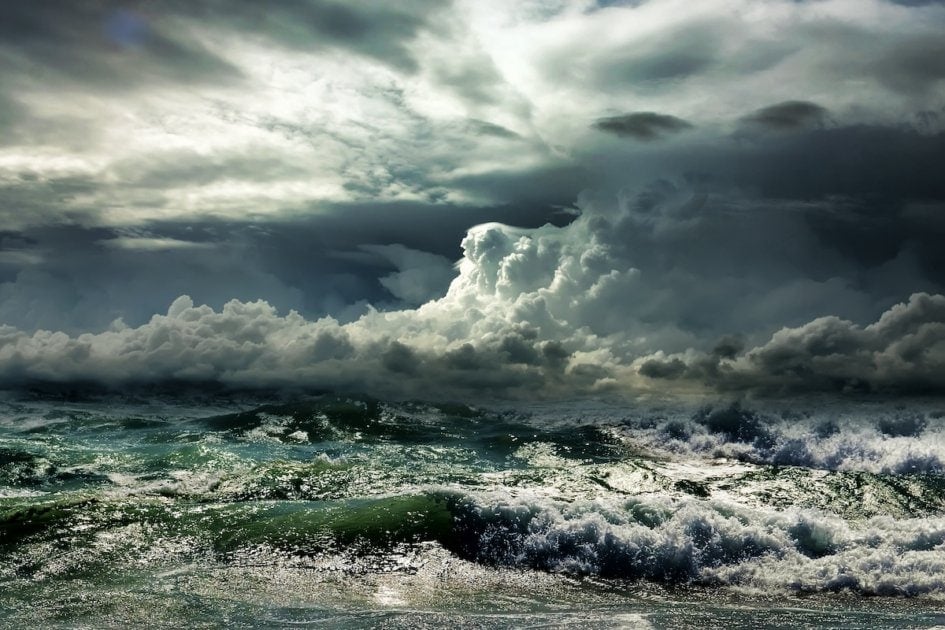
Barometric pressure, also called atmospheric pressure, is how the pressure of the atmosphere is measured based upon the gravitational pull—what we would think of as its weight—at a specific point. As a reference, the standard barometric pressure at sea level is 1013.2 millibars. When warm air runs into cold, Arctic air, the wind converges in the center, pushing air up higher causing the atmospheric pressure to “bomb out” into the 900 millibar range. The lower it goes, the stronger the storm.
For those who depend on the weather, keeping an eye on falling pressure is important, as it typically indicates bad weather is brewing. It’s often when fishing isn’t as productive and, for those who pay attention to them, animals’ behavior changes in preparation for a storm. When a storm bombs out, the result can range from a fairly typical winter storm to heavy snow or rain, resulting in drifts or flooding, along with Category 1 hurricane force winds of over 74 mph.
Hurricane-Like, But Not Hurricanes
And while bombogenesis might have some of the features of a strong oceanic storm, it shouldn’t be confused with a hurricane. Even though they are sometimes called winter hurricanes, there are key differences:
- Moldan notes that bombogenesis most often occurs east of the Continental Divide, often happening in the Northeast, although some of the biggest blizzards on the plains can also be attributed to this phenomenon.
- For a “bomb cyclone” to occur, it’s a function of the air masses interacting, which is why they typically form in the late fall to the early spring when there is ample cold air in the system. A hurricane, on the other hand, gathers its energy from the warm ocean water. Sometimes the two storms can converge on the coast, such as what happened in 1991’s “Perfect Storm,” but for the most part, bombogenesis often produces larger storms—sometimes stretching 1,000 miles wide over a land mass—making them particularly memorable.
Notable Bombogensis Winter Storms
| Date | Storm | Lowest Pressure in Millibars (mb) |
| March 11-13, 1993 | “Storm of the Century“ | 960 mb—dropped 33 mb in 24 hours |
| February 7, 2013 | “Winter Storm Nemo” | 968 mb—dropped 29 mb in 24 hours |
| February 9, 2016 | “Winter Storm Mars” | 979 mb—dropped 26 mb in 18 hours |
| March 9-17, 2017 | “Winter Storm Stella” | 974 mb—dropped 31 mb in 19 hours |
| January 3-5 2018 | “Winter Storm Grayson” | 957 mb—dropped 53 mb in 21 hours |
“I was in South Dakota at the time of a very intense storm on October 26-27, 2010. There was a record low pressure for Minnesota of 955 millibars. The previous record was 962 millibars.” Moldan says.
With winds gusting to 79 mph in some areas, 10-foot waves made life challenging to those living or working on Lake Huron and Lake Michigan, while the tallest wave recorded during the event topped out at 27-ft. on Lake Superior. The winds also caused significant structural damage to buildings, plus took down power lines and damaged trees. Although the heart of the storm focused on Minnesota and Wisconsin, the storm’s reach impacted areas from eastern Montana to Pennsylvania, all the way to Arkansas and Tennessee.
While bombogenesis might be a relatively new term to many of us, it is good to know the meteorological magic behind some of the dramatic weather events it brings, and why, if you hear that the storm is going to “bomb out,” you know to hold onto your hat!


Amy Grisak
Amy Grisak is a freelance writer, blogger, and photographer specializing in gardening, local food, and stories about her home state of Montana. She enjoys sharing her experiences with self-reliant living and outdoor recreation. Her article on the "hugelkultur" gardening technique appears in the 2021 Farmers' Almanac. You can follow her topics on her site, AmyGrisak.com.
-
Amy Grisak#molongui-disabled-link

-
Amy Grisak#molongui-disabled-link
-
Amy Grisak#molongui-disabled-link
-
Amy Grisak#molongui-disabled-link


Thank you good to know info!